| |
| |
Col du Glandon
Together with the
nearby Col de la
Croix de Fere, this pass lies at the center
of cycle racing activity in the western alps. The
two passes are associated so closely, that
sometimes going over the Col de la Croix de Fere
is described as an approach to this pass, and that
even though Croix de la Fere is then the highest
point. - Not so on this page. Below are the only
two approaches for wich Glandon is the highest
point.
But it's not only these two summits that provide for heavy cycling traffic in the summer. It's also the surroundings, the climbs of Bourg d'Oisans to the south, as well as Col de Madeleine to the north. One special thing about Col du Glandon is a long stretch above tree line in a high alpine valley. The road has a smooth surface. During my traversal on a day in June cyclists outnumbered motorcycles by at least 20 to 1. Those outnumbered cars again by maybe 10 to 1.
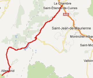
From South. This side is also a tour of
damns. Right past Allemond the road crosses the
first one. Judging from the number of bicycles I
saw around town, even more cyclists call Allemond
their vacation home than Bourg d'Oisans. The bike
traffic on the damn is heavy. In cool morning
shade the Chaine de Belledonne looms to the left,
still snow covered in mid June. But the road
remains below in the forest. The first interesting
views come just before reaching le Rivier
d'Allemond. Here the road makes a very noticeable
descend to cross Eau d'Olle below. Above the Grand
Pic de Belledonne (2978m) looms over the mass of
green hills.
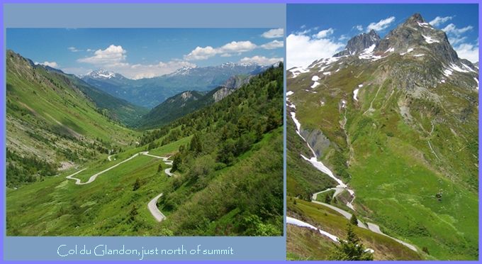
After climbing the bare slopes above the damned
lake, the road descends again, almost to lake
level. Ahead you can see a long bare valley,
shaped like a gigantic roof gutter, the road
weaving back and forth in it, much like the path
of ball rolling down from the edge of a giant
inclined half pipe would take. At the junction
between the tops of Glandon and Col de la Croix
de Fer stands a solitary restaurant. From
here the top of Glandon is less than 50 meters
higher. Glandon is really a shoulder point on
Croix de Fer. From North. (described downwards) The
interesting high peaks scenery remains on the west
side, These peaks in the Belledonne Range top out
at just below 3000m. This road is quite a bit
narrower and curvier than the other side. Several
picturesque villages all surnamed "des Villards"
appear in close distance to the road, without that
the road passes through them. Colomban des
Villards is the most obvious one and has the most
interesting mountain backdrop.
Historical Notes.
The first road over the pass was opened in 1898. In 1908 it was connected to the Col de la Croix de Fere. Between 1947 and 2012, the pass was reached on 12 stages of the Tour de France. Many of these routes continued to climb to the Col de la Croix de Fere. A day on an
extended tour: (<Col
de la Morte|Col
de la Madeleine>)
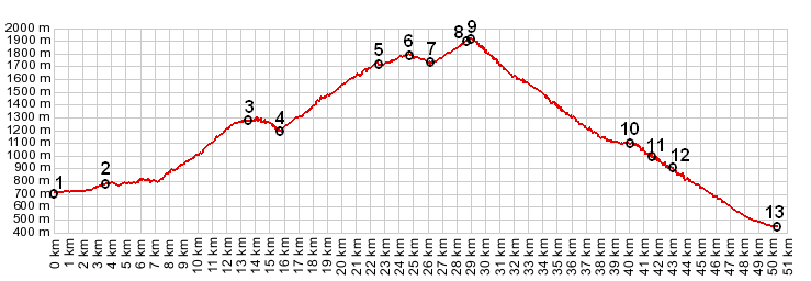
Col du Glandon: Bourg d'Oisans > Allemond > Col du Glandon > St Alban des Villards <> out and back shopping trip to bottom of valley in St Etienne de Cuines: 47.3miles with 7010ft of climbing 5:41hrs (VDO MC1.0 m4:12.6.15) |
 Approaches
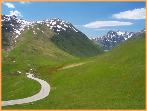
|
|
advertisement |
|
|
advertisement |