|
|||||||||||||||||
|
|
|||||||||||||||||
| |
Col de Sarenne (including Alpe d'Huez)
The climb up to Alp d'Huez is probably the most famous stage
on the Tour de France. Its grand finish is located at a huge
ski resort. On the other side of this mountain is a totally
different world. Connecting them is the Col de Sarenne. One
of its approaches includes the Alp d'Huez climb, and the
difference between the two approaches is what makes this
pass ride so unique.
From West. The climb up to Alp d'Huez starts
immediately from the roundabout on the north side of the river
Romanche, outside Bourg d'Oisans. The town sits in one of the
wider spots of the Gorge of the Romanche. This climb is perfect
to show off the magnitude of this landscape, as well as remember
favorite scenes from the Tour de France. Seen from the lower switchbacks, the road on the opposite
side of the valley leads to Villard Nortre Dame. It seems to be
edged into the cliff along a ruler straight line, seen from this
foreshortened vantage point. As the road rounds an old church
tower with the belfry just above eye level, the valley takes a
step back, and so the road also enters into a new bowl in the
landscape. Switchbacks come, switchbacks go. The valley takes another step back and the road enters the first signs of approaching resortdom. Finally the road splits into ski lift bound traffic on the right and "Itineraire Tour de France" bound traffic on the left, bound for uptown Alp d'Huez so to speak. Both can be used as approach to Col de Sarenne. The ski lift route is a little shorter, but once up here, who would not want to check out the scene of this curious resort landscape, where so many races have been decided. The last km of the course still climbs, now flanked closely by cafes, hotels, offices and other businesses. It's a town of countless small box shaped houses. They all seem to sit on top of one another and crowd in the road, and through the middle of this cubist landscape threads a ski lift. The road tunnels partially under all this in one last switchback, all very much like a toy world. You may recognize the scene from a million TV shots. A tour de France banner over road remains up permanently. The road is densely lined with small open businesses. But fortunately all the inflatable advertising gizmos are gone. The change in scenery is near. The road to Col de Sarenne can
be found by riding higher into the ski resort hotels, heading
for the highest one of them all - the Club Med hotel - or
following signs for the airport, which here is also labeled with
the curious name "altiport". If all else fails, look
for parking lot 4 also works, and at the end is a very different
world - and a very different road - barely paved where the
patches on top of the patches didn't hold. We now head above
treeline.
From the start of the patchwork road, another road can be
seen far to the right crossing a gap between two mountains. This
route turns out to be unpaved, and is not the Col de Sarenne
route. Instead the Col de Sarenne route drops, and then follows
a shallow treeless tundra valley towards the left to the summit.
The altitude here is just a little higher than Alp d'Huez.
"You're almost there" said one rider to me passing in
the other direction. I was surprised that he made no attempt to
communicate in French first. The view of three nearby peaks
accompanies the cyclist to the top. But the distant views are
hidden behind the slopes of this low grassy ravine. The highest
of these nearby peaks is the Pic du Lac Blanc at 3327m. When I
reached the summit, most of the clouds lifted from the Gorge de
Romanche. But upsloping winds from the valley of the Ferrand
still filled the eastern side of the pass with dense clouds.
From South. (described downwards). But a little ways
down the eastern side the view improves greatly, and the
windblown clouds act like a soft filter on the light. The
switchbacks of the road hang between the mountains dissolving
into clouds, and snow on top. Houses with large tent like roofs
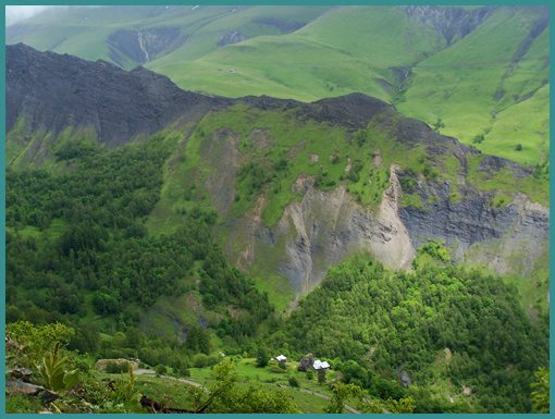
hide in the crevasses below. A mountain face next to these
houses shines like a metal surface in the curious light. It
looks like a slip face of a former landslide. History- Cycling - Tour de France The climb to Alp d'Huez on the is arguably the
most famous climb in the world for bicycle racers. As of 2012,
since after WW2 the climb has been part of 27 Tour de France
schedules. 1952 was the first time, and it was won by the
Italian Fausto Coppi. It took 24 years for the tour to return to
this climb. But since 1976 the climb is regularly on the
schedule. Each of the switchbacks (here called levels) carries
the name of a stage winner. Since Lance Armstrong won the climb,
the number of stage winners exceeds the number of switchbacks,
and now some switchbacks have two names. Lance Armstrong and
Fausto Coppi now share a switchback. No word yet on what is
going to happen to this situation since Lance Armstrong lost his
titles. The fastest time for the climb is still held by
Marco Pantani during the zenith of the EPO doping period.
But measured best times over the years differ for other reasons
too. For one thing the finish line has been moved over the
years. Only three racers were able to win both this stage and
the entire Tour de France. They were Fausto Coppi in 1952, Lance
Armstrong in 2001 and Carlos Sastre in 2008. Dayride with this summit as
highest point:
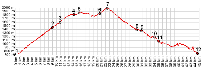
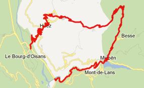
Col de Sarenne: Bourg
d'Oisans > Alpe d'Huez > Col de Sarenne > Clavens
> Mizoen > N91 down Gorge de la Romanche > sp:
42.4miles with 5350ft of climbing in 4:30hrs (VDO MC1.0
12.6.13).
Notes: includes about 10 extra out and back miles on N91, and touring around Alp d'Huez The last summit ride with different start and end points on this Extended Tour is on the page: Col de Morte
back to Cycling
Passes in Europe
|
 Approaches