| |
| |
Col de Pitons
Mont Saleve is a 18km long,
mostly forested ridge south of Geneva. On a clear
day the ridge is a perfect far vantage point onto
Geneva as well as the western alps. This mountains
has two named paved passes and one named summit.
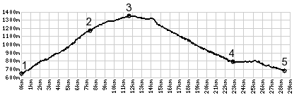
Col de Pitons is the highest of the three by a few
meters. Of the three it is also the quietest spot,
with the best views onto the western alps from its
upper southern approach. But of course you could
ride along the crest over all three summit points.
The profile leaves all these businesses behind
and turns south along the ridge. The road stays
east of the crest, and in the beginning there are
a few views of Lake Geneva, which form this
vantage point can be seen with its length
compressed. A few wide curves meander scenically
above treeline - but then - even though still
climbing ever so gently, the road enters forest
again. And that's when you find a sign next to the
road stating "Col de Pitons 1335m" From South. There is
no view from the summit, and the road stays at
roughly the same elevation for maybe about 2 km. I
found a particularly nice picnic bench under a
shady tree for my lunch stop a few km further
down, with the panoramic view from the Chartreuse
to Mont Blanc onward to les Voirons. Three out of
the four pictures below were taken at that spot.
Past this, the long meandering descent starts
gently and continues for a total of many circles
of rotation to Cruseilles. Staying on the signed
bike route ,the Mont Saleve boucle, the road
climbs slightly again towards the north. But
choose any other direction and the downhill
continues. For example, the profile descends
towards the west to a low point between Mt Salveve
and the Plateau des Bornes
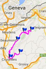
Dayride with this point as highest
summit: COMPLETELY PAVED: Col des Pitons , Mont Saleve
northern summit , Plateau des
Bornes s(u) : Annemasse > Monte du
Mont Saleve > Col de Croisette(shp) > Col de
Pitons > Cruseilles > D278 and others west
> following signs for Plateau des Bornes Sud
bike route > La Chapelle Rambaud > Plateau
des Bornes s(u) > La Roche sur Foron > back
to starting point in Annemasse with detours:
55.4miles with 4918ft of climbing in 5:37hrs
(Garmin etrex30 m4:14.7.16). the last day with different start and end points
on this tour is on page: Mont Saleve
northern summit
|
|
|
advertisement |
|
|
advertisement |