| |
| |
Col de Rousset
This is the only paved climb onto
the top of the Vercors plateau from the south.
Nearby Col de Menee
also climbs an outlier of the Vercors plateau, but
then immediately descends it again to the west.
The road to Col de Rousset is wider, and has more
traffic than many of the peaceful little paths in
this area, that one can get used to. There were
even some trucks. But by the afternoon I seemed to
have the road to myself again in this last week of
April.
The long traverses work themselves up a slope,
across from a large limestone cliff. Finally - a
sign. The top is only a km or two away and less
than a hundred meters higher. But something is
wrong with this picture. There are many roadcuts
above a 100 meters, and the remaining cliff also
seems much higher than a 100 meters. Just before
reaching it the answer appears : it's another
tunnel of course. This one is 1700 meters long,
well lit, and well behaved, that is to say
straight as an arrow. As for the roadcuts above the tunnel: All roads
leaving from this side of the tunnel end within a
km.
From North. But on the
other side of the tunnel a signed turnoff leads
5km to the base of ski area parking lot. No great
extra views can be earned with the climb, unless
you start a hike from there. Descending from the summit, after a km or less
you have the choice to remain on this windy
plateau top and head left for Vassieux en Vercors.
This involves another small climb over a
nondescript forested summit, almost as high as
famed Col de Rousset, and marked as Col St Alexis
on one of my maps. Or you have the choice to descend into a high,
long, straight valley on the plateau, with only
one single zig and a zag. Down there below waits
the little village Rousset clustered around its
church, that gave the pass its name. Nothing in
this bowling alley valley stops the wind. It seems
to just use this conduit as a kind of accelerator
- all the way to St Agnan.
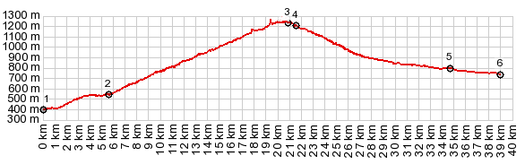
Dayride with this point as highest summit: COMPLETELY PAVED: ( < Col de Bataille | Col de Menee > ) Col de Rousset x2 , Col de St Alexis , additional out and back: Die > Col de Rousset <> out and back to ski area at the top[1] >> down north side of pass to turnaround point in St Agnan << back up north side of Col de Rousset <> out and back on D76 over Col de St Alexis > turnaround point just before entering Vassieux en Vercors << Col de Rousset > back to starting point in Die with downtown detour: 62.3m with 6187ft of climbing in 6:14hrs (garmin etrex30 r5:19.4.29) Notes: extremely windy and as cold as any April has ever been. Col de St Alexis is only marked on one of my maps and there is no sign or other indication of this designation. The day also included a walk to the ridge from ski area[1] 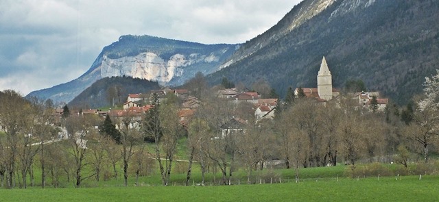 History The tunnel - and and with that the pass, owes its existence to the ski area on top. The first beginning hotels to house skiers in this area were built in 1927 in La Chapelle and Romans. Back then skiers hiked to the top.  left:
the village Rouset, as seen from the road to Col St
Alexis. left:
the village Rouset, as seen from the road to Col St
Alexis. |
|
|
advertisement |
|
|
advertisement |