|
|||||||||||||||||
|
|
|||||||||||||||||
| |
Col des Saises
This well traveled pass road has a ski resort on top. The
wide road and the extensive housing infrastructure on top is
a good recipe for a Tour de France pass. - And the
pass has been on the route many times in recent years, but
never has a stage ended here. For me the best thing about
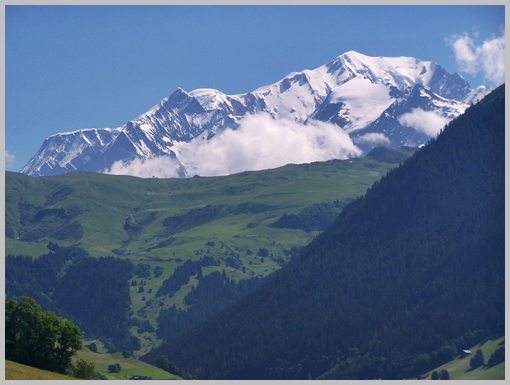
this road: There are the most amazing views of Mont Blanc.
From South. D218, a regular wide road with fairly
heavy traffic leaves the valley of the Doron between Villard sur
Doron and Beaufort. The map also shows a smaller road on this
side. It connects the lower southern Villard sur Doron with the
main approach, D218, shortly before the top. Usually smaller
roads are better. However I suspect that in this case the small
road may miss the major attraction on this ascent. There are a
few glimpses of what's to come further down. But the
uninterrupted view comes just as D218 turns away from Hauteluce
and its route up Col du Joly. Mont Blanc appears behind a green
ridge, consisting of frozen white ridges, still in mid June. And
these ridges are in control of the clouds and the weather. These
views last for several switchbacks until the road enters the ski
resort of Saises, located on a loaf shaped mountain.
From North. (described downwards). After the view of
Mont Blanc on the other side, it's hard to compete in the
scenery department. The Chain de Aravis is equally steep, just a
lot lower. Approaching Flumet at the bottom, a D road on the
left makes a short cut into Flumet. It enters with a nice view
from above, the village houses hanging over the river Arly
precariousely. Crossing the bridge over the Arly, and
immediately afterwards crossing the main road, the route heads
right up the next pass, Col des
Aravis History- Cycling- Tour de France: Ski resort
towns are always a favorite of large organized bike races.
Saisies is no exception. Up to 2010, the pass was 11 times on
the Tour de France schedule: 1979, 84, 87, 92, 94, 95, 2000, 02,
06, 09, and 2010. Dayride with this pass as
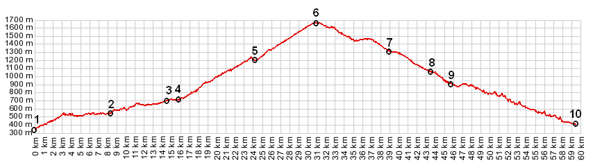
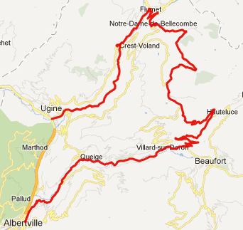
highest point:
Col des Saises , Col
des Aravis , Col de la
Croix Fry , Col de l'Epine
, Col de la Forclaz :
Queige > Villard s Doron > Col des Saises > Flumet
> Col des Aravis > Col de la Croix Fry > Montisbrand
> Col du Marais(shp) > Col de l'Epine > Marlens >
Ugine > Col de la Forclaz > sp: 72.0miles with 9470ft of
climbing in 7:12hrs (VDO MC1.0 m4:12.6.22)
Notes: last pass included a bag full of groceries The last pass ride with different start and end points on this Extended Tour was: Cormet de Roselend back to Cycling
Passes in Europe
|
 Approaches