|
|||||||||||||||||
|
|
|||||||||||||||||
| |
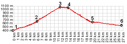
Col St Leger
This partially unpaved crossing has the expected rewards: a
virtual absence of traffic and great scenery. But there is
another unique attraction to this crossing: passing several
Roman looking bridges along the way.
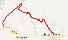
From East. The approach starts by turning off N202
directly opposite the modern hanging bridge in Puget-Theniers.
Signs show the road as direction Roudoule. For several km the
road follows the gorge of the Roudoule close to its bottom. Then
the route turns to the left, from D16 onto D316, below the town
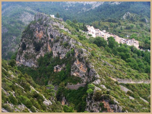
of la Croix sur Roudoule. This turnoff to St Leger and the
bridges used to cross the gorge is the most memorable point on
the ride. There are two bridges: on old stone arch bridge below
and a second modern hanging bridge, used to carry today's
traffic. The climb on the opposite side turns out to be a
vantage point on the lower part of the road, as well as onto the
precarious perch of Croix sur Roudoule. From here it is also
easier to recognize a third small Roman looking bridge far below
in the valley. There is a sign, marking the Col on top, just
where the snow covered Mercantour Range comes in sight. A trail
from here can reach another 100m higher. At least one looks like
it would be readily mountain bikable. From West. A relatively short descend ends in the town
of St Leger. The road seems to dead end at the small town
square. Going back about a hundred feet you can descend to the
right of the square and then take another unmarked left down a
narrow roughly paved path. The road passes by a farm and
descends in curves to the valley. The Gorge de Daluis comes into
sight. It has a Himalayan appearance from this spot because of
the extreme width of gravel braids. There is a short unpaved
section where the path crosses a talus slope. It is so short it
could easily be walked without much loss of time. The route ends
with yet another memorable bridge, not as historic as the
previous three but very necessary to complete the loop. It is
used by D2202 to cross the Daluis. Its size keeps cars over 2
meters wide away from this path.
A Dayride with this point as intermediate summit is on
the the D17-D27
Rourebel(sh) page
The last summit point on this Extended Tour with different start and end points is Col de Felines back to Cycling Passes in Europe
|
 Approaches