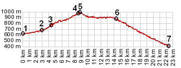
|
|||||||||||||||||
|
|
|||||||||||||||||
|
|
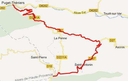
D27 - D427 Rourebel(sh)
This point is on a Bucles d'Azur bicycle route. It is
located at the intersection between D17 and D27, a short
distance below Rourebel, on a shoulder of the D27 Ascros
summit. Col de Saint Raphael is a shoulder point on the
northern approach.
From South. The starting point of the profile connects
with the Col de Trebuches
profile. Starting at the southern end of that profile, then
turning right onto an even smaller, quieter forested road, a
sign warns that picking mushrooms is strictly forbidden in these
local forests. I'm sure somebody picks them though.
From North. But the profile turns left and descends to
Col St Raphael. The town of the same name on the south side of
Col St Raphael can be seen from far above before reaching this
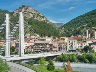
pass. From here a curvy descent leads to Puget Thenieres, with
the mountains of Mercantour Park now a lot closer. Arriving at
the endpoint of the profile, the road crosses the Vars on the
easily recognizable hanging bridge. Up or down valley, from
here on the traffic is a lot heavier. But you can also go
straight on the other side of the bridge and cross the
partially unpaved Col St Leger.
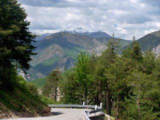
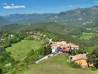
top left: view
north form Saint Antonin, top right: descending Col St Raphael
to Puget Theniers
Dayride:
D17-D27 Rourebel(sh) , Col de Trebuches , Col St Leger, additional out and back: Entrevaux > up D610/710 > Col de Trebuches > la Rochette > St Piere > St Antonin > D17-D27 la Penne(sh) <> out and back to Ascros > col de St Raphael(shp) > Puget Theniers > Col St Leger > down D1202 > back to starting point on left side of Var on a trail from supermarket: 62.4miles with 6880ft of climbing in 6:20hours; (VDO MC1.0 m4:12.5.23) The last summit point with different start and end points on this Extended Tour is Col de Felines back to Cycling
Passes in Europe
|
 Approaches
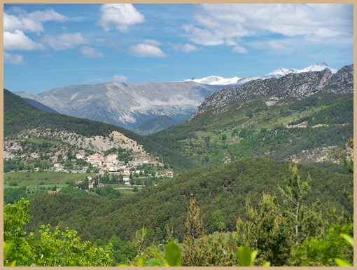

| advertisement |
|
| advertisement |