Stilfserjoch
aka Passo Stelvio
For road cyclists Passo Stelvio is the most
famous, or infamous pass road in the alps. It has
the highest "cult status". When it comes to the
very highest, completely paved roads, this road
comes third after the Cime de la Bonette, which is
not a pass in the classical water divide sense,
and also after Col de l'Iseran by only a few
meters. Some sources disagree. But then life
really has not that much to do with numbers, at
least the interesting aspects of life. The scenery
is what is magnificent, and the way the road
interacts with it, in tunnels and galleries, and
switchbacks, all of which are result of a
turbulent history.
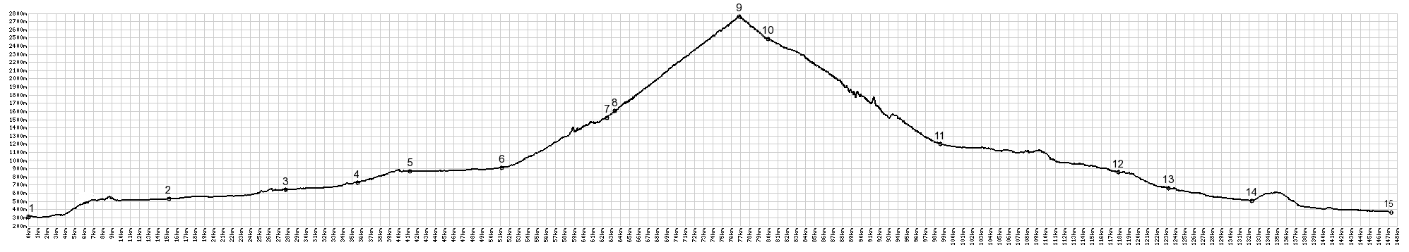 |
01.(290m,00.0km)
START-END NORTH ALT: Meran
02.(520m,15.2km) Naturns
03.(640m,27.8km) Latsch
04.(740m,35.6km) Schlanders
05.(860m,41.2km) Laas
06.(930m,51.2km) START-END NORTH: Prad am
Stilfserjoch
07.(1520m,62.5km) Trafo
08.(1580m,63.5km) turnoff to Neuwies
09.(2757m,76.8km) TOP: Stilfserjoch
10.(2470m,80.3km) jct with Umbrail Pass
11.(1260m,98.6km) START-END SOUTH: Bormio
12.(860m,117.9km) Sondalo
13.(660m,123.3km) Grosio
14.(520m,132.4km) Lovero
15.(370m,147.2km) START-END SOUTH ALT:
Tresenda
|
 Approaches Approaches
From North. (described
upwards) The first part of the elevation profile
is a representative route from Meran to Prad, to
show that there is some elevation gain involved
here. The map does not necessarily follow the bike
path all the way. But there is one, a wonderful
and famous route following the river Etsch.
Most people agree, the real climb up Stilfserjoch
starts in Prad. Exiting Prad, the elite start
their time measurements. I enjoy the view and the
peace. Here it's still just a quiet road through
deep forest. It was early afternoon and the
majority of motorcyclists were still sitting
around consuming food and drink, and when they do
that their motors are turned off, and they don't
make nearly as much noise.
Between the carpet of green leaves, a sliver of a
white wall ahead gives hints of what is to come.
Past the turnoff to Sulden, it becomes clear that
the road is climbing a ridge across from the main
wall in the Ortler Group. Two hotels, solid
rectangular rock boxes, not the stapled together
cardboard housing I am used to, takes advantage of
this green perch across from the white wall. The
switchbacks are numbered, and I wish I had paid
more attention so that I could report their
impressive, staggering number out of own
experience, but in a way it was too many to be
meaningful while trying to get enough energy to
ride up them. Besides, you can look these things
up. There are 48 of them on this side. The first
one stands at 1541 meters near Trafoi, after
exiting some newly built gallery tunnels.
Hours pass and the switchbacks work themselves to
way above treeline. Another large old hotel marks
the first complete view of the final section of zig
zag heaven, the historic stone complex at
Franzenshoehe. The place is switchback 22. 550
meters of climbing over 6.6km distance remain. The
route has now managed to include an overall
direction change into its zig zag squiggles. With
every switchback closer to the summit the scheme
becomes clearer, zig: climb north east, zag: climb
south west but just a little further ... repeat.
Still when the sign next to the stone wall
separating the road from the drop says 5km to the
summit, it just looks like a stone's throw away -
but only a stone thrown form above, which reaches
much further. But then when the sign reads Kehre 1
(switchback 1) it comes as a complete surprise. Some
of the summit buildings visible are actually quite a
ways above the road. The view back down from
switchback 1 is one of the great mountain road
photographs that I have seen in books repeatedly, or
it may have been switchback 2. At this point I
really was tired enough, not to notice the
difference any more.
Slideshow of Northern Approach
From South. (also
described upwards) Again the profile starts much
lower, than where cyclists start their day to
climb this pass: all the way down in the town
Tresenda. Leaving Bormio, there is very little
time to warm up. The road start climbing right
away. Several valleys radiate out from Bormio,
which sits at the hub of several mountain passes.
Opting for Stilfserjoch, you don't see much of
Bagni di Borno, the bath where the nice lady at
the visitor center told me I could have a room for
several hundred euros. Thanks, maybe another time
... in another life.
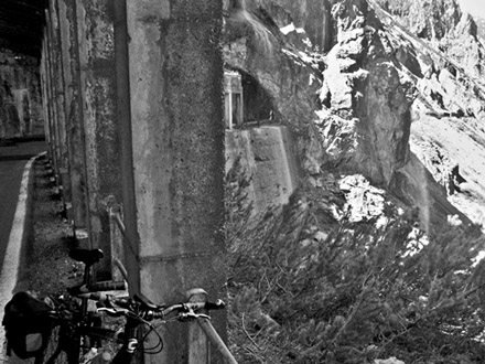
But after that it gets interesting right away.
The road enters the sheer sided canyon of the
torrente Braulio at half height. Rather than
clinging to the side on a shelf, the road uses a
whole series of galleries and tunnels. During a
morning in June, water is dripping around the
portals like a curtain. On the return, during the
late afternoon of this now hot summer day the
curtains become waterfalls. There are a total of
six of these antique appearing gallery tunnels.
The longest is 250 meters long. All now have
lighting. The lower galleries have a smaller
tunnel diameter, and seem like something
appropriate for a small 1950s Triumph car, for
example.
After this exciting gallery traverse you find
yourself at the bottom of endless zigzags. With a
slope of 12 percent, these 14 switchbacks are the
steepest section on this side and gain 300 meters.
And above that, who knows ? Above the last
switchback only sky is visible. Again an
albergo/ristorante fronts a stream, that becomes a
waterfall during the return. Looking down, while
turning from a zig to a zag, and catching my
breath, the vertical sides along the Torrente
Braulio seem to disappear into the bottomless.
The road now enters a treeless high alpine tundra
valley, the Bocca del Braulio. For now, no more
switchbacks are necessary to climb the grassy
waves. The road passes an old Canton House, a sign
explaining the WW1 situation at this location.
At the junction with Umbrail
Pass sits another old Canton Building, now
closed down, the window shudders painted a vibrant
blue. Its picturesqness derives not only form the
decaying walls, but also that no motorcycles are
parked in front of it. The top of Stelvio and a
few of its old albergos are now plainly visible.
One can gauge the work, that is left to reach
them, surrounded by all that snow. It still seems
to take considerable effort to reach Stilfserjoch
from here. So now is a great time to observe, that
Umbrail Pass, the highest Swiss road pass, is
really only 2km distant, as the crow flies, from
the highest road pass in the alps. Don't think I
have to name it again. - But from down here you
have no idea of the street fair atmosphere waiting
up there.
Past the jct with Umbrial
Pass, the road executes sweeping turns
between peaks and power poles. I want to call it
an industrial wilderness. Focusing between the
powerlines, you can find a world of mountain
vistas in two directions, down beyond Umbrail Pass
and back to where I came from. But - just the
facts please: this last section is 3.5km long and
climbs the last 6 of the total 36 switchbacks on
this side, climbing a mere 200 meters. - Not a
fact: it feels like more.
Finally reaching the top, a small distance before
having a chance to be diverted by the stunning
vista of switchbacks on the other side: Is there
something you would like to buy ? Well maybe not a
stuffed animal, that would be too hard to carry
back down on the bike. But maybe a Stelvio Jersey.
There are probably several hundred to choose from.
- or anything else you can wear, eat, drink, send
in the mail, look at, or put on a shelf.
Apparently there are also a bank, so that access
to money should not be a deterrant for commerce on
Stelvio Pass. And what else would you possibly
want to do in all that grand nature, but visit a
musum of it, the Stelvio Museum on top. To be
fair, if I could or ride up here every week, this
would probably be a wise way to spend my time. But
this time around I didn't see it between all the
other sale items, and sausage sale booths. And to
put things in perspecitve regarding the commerce:
Of course, nobody approaches you and presses you
to make a purchase, like in an Asian street bazar.
This is still civilized Europe. The goods are
there if you want them. Some do, some don't.
Slideshow of Southern Approach
A final note, as a reminder to myself, since I
forget things so easily ... about timing: As is
often the case, cyclists and motorcyclists often
have the same geographic goals, even if their
goals in life in other aspect don't intersect that
much. I had the absolute perfect weather on my
ride, and so did the thousands of motorcyclists.
Even if I picked the right weather (actually it
picked me), I picked a bad time, or date: the
Pentecostal holliday in northern Europe, when
thousands of motorcyclists (but certainly not all,
that would be hundreds of thousands) celebrate the
resurrection of Christ by seeing how close they
can come to death, or at least make enough noise
with their engines, to scare away life any with
funtioning ears. It was an internationally
occupied road. But I noticed a few differences.
Their were motorcycles from Belgium, the most from
Germany, lots from Austria. The ones with the
girls on the back, their butts hanging over the
back of the bike like a gothic Christmas tree
ornament, were at least 90 percent on Italian
bikes. I guess those were the local day trippers.
There was also a very small contingent of motor
cyclists with an american look to it. The bikes
with the handlebars so high, the riders look like
they are trying to do pullups, but can't because
... of a number of factors.
Historical Notes
In some books it is written, that this pass was
used in the bronze to get goods from Tyrol to
Italy. But it seems obvious that Umbrail Pass was a
much easier, therefore and more often used
crossing.
In the early 19th century Italy did not exist as a
country. Instead a small group of European
imperialist types parceled out the continent
between themselves. Historically this is known as
the Congress of Vienna at the end of the
Napoleonic Wars. The northern end of today's
Italy, Lombardia with Milano as its capital, was
given to the Hapsburg family, who ruled the
Austro-Hungarian Empire. In order to connect this
part of Lombardia with the rest of their empire,
they wanted (or needed) this road, which does not
stray into Switzerland, as Umbrail Pass does.
After years of unsuccessful attempts, they
finished a road across the pass in 1825. This gave
them a clear line of transport from Austria into
the dolomites up into the Val Venosta and
Valtellina areas.
In the 1860s Italy managed to unite and gain
independence. The top of the pass was now the
border between Austria and Italy. During WW1
Italian soldiers confronted Austrian soldiers over
a distance of 50km, stretching along the ridge
line between Passo
Gavia and Stilfserjoch. Signs along the road
on the Bocca di Braulio point out the
strategically most important peak in the Stelvio
area: Monte Scarluzzo (3091m). It was taken by
Austrians and stayed under their control until the
end of the war. Today the trenches, paths and
tunnels make hiking destinations.
But then, before WW2, Hitler gave German speaking
South Tirol to Italy, as part of the allegiance
between the two allies. Suddenly both sides of the
pass were now Italian. (Are there any other
European passes that have such a turbulent
national history ?) This eliminated the original
purpose, for which the pass was constructed, and
its importance diminished. Prior to this event,
there was a period when the pass was kept open
year round. This period ended once and for all.
The road was paved in 1938, and for a time was
regarded as the highest paved pass in the alps.
Many people believe that this is still true.
Nowadays there are several passes in this range,
where the difference in elevation falls within the
margin of error: Col
d'L'Iseran (2770m) in 14m higher, Col de
Agnel (2744m) 13m lower. Col de Restefond
with 2715m is actually 42 meters lower. But you
can argue, that starting at sea level on the
Mediterranean it has by far the biggest elevation
gain. There is also an additional loop on top of
Col de Restefond, called Cime de la Bonnette, that
makes it up to 2802m, that is 45m higher. But this
is not a recognized pass, but instead a scenic
loop road. Expanding the view beyond the alps to
all of Europe, there is also a higher paved out
and back road to the Pico Veleta area in the
Spanish Sierra Nevada which reaches a much higher
elevation.
Cycling: Fausto Coppi was the first to
get to the top of the pass as part of the Giro
d"italia in 1953. In 1961 the race went over the
top and finished in Bormio, won by Charly Gaul.
More often than not, the race finish has been held
on top of the mountain.
In 1956 and 1972 and 2012, the Giro went up the
Bormio side of the pass, and through all its
tunnels and galleries. Surprisingly, this is one
of the few slopes where the descent has often been
more instrumental in deciding who gets across the
finish line first.
You might expect that cancellation of a stage like
this is a major risk, and you would be right, 1988
because of snow
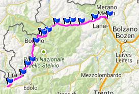
Dayride
PAVED/ VERY SHORT SECTION UNPAVED
Stilfserjoch, Umbrail
Pass: Bormio > Bagni di Bormio >
Umbrail Pass > Sta Maria > Taufers > Prad
> Stilfserjoch > back to Bormio: 67.7miles
with 10442ft of climbing in 6:56hrs (Garmin
etrex30 m4:14.6.8)
Notes: this measured 64.0 miles with 10008ft of
climbing in 6:40hrs using the VDO MC1.0 with
wheelsize set to 79.8i
The last day with different start and end
points on this tour was: Passo Gavia
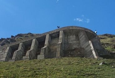
top left: some
of the the switchbacks from below look a bit
like the buttresses to a gothic churchbr>
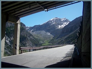
bottom: the view from inside one of the old
and narrow gallery tunnels
|