| |
| |
Wuerzjoch
aka pso delle Erbe This pass has several options for
approaches that meet near the summit, so that
traffic thins out considerably. The route that I
happened to ride is in (in places) especially
narrow and steep. This route is longer and
involves more climbing than it appears on the map,
due to a winding road and a complex topography.
Much of the appeal of this route are villages,
either passed through by the road, or apparently
glued to opposing slopes, that when seen
foreshortene in the distance, all seem to lie on
top of one another. That's not to say that the
mountain scenery is any less interesting, after
all it passes through a natural park area between
several dolomitic Kofel.
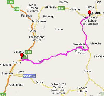
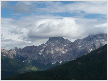
From West. There are at least two major options that meet not far below the summit. One option is to start climbing in Brixen. The other option is described here. It follows the val di Funes from the north end of Klausen (Chiusa). There is no exit sign from the Brixen - Bozen bicycle road, which only shows, that even the world's most perfect bicycle path system could be improved. Before entering Klausen from the north, the bicycle road goes under a bridge over the river Eisack. At this point it's time to turn around, take the previous bike path exit, and take the aforementioned bridge across the river Eisack, together with the cars. At a traffic circle on the other side, you head back north for about half a km, and then start climbing in steep switchbacks to Guidon. There is little traffic on this road, and traversing Guidon via the narrow road, it's easy to take a wrong turn and end up at a church below the colorful statue of Sankt Nepomuk, whoever he is. Guidon has lots of breakfast pensions, and looks like it would be a good base camp. Once the way is found out of this little village, the narrow road descends for a while, and then picks up a larger road that leaves from the Eisack valley further north. But the number of kms on a a regular road are numbered. Turning left in Sankt Peter, now following signs to Wuerzjoch, the words narrow and the phrase "steep and narrow" takes on a new meaning, something akin to steeper than a staircase and narrower than a hallway. Understandably, there is not much traffic here, and it is well behaved. Even the motorcyclists slow down, maybe because they can't get up enough speed to kill themselves in one fell swoop. This is really a one way road the width of a bike trail, with dirt turnouts. The largest cars up here are the public microbuses that serve the bus stops. When two meet, they cause a traffic jam because one has to back up. The good news is (as said) that there is very little traffic. The bad news is that just a car passing a bicycle in the opposite direction is a major operation. The road is so exciting, the incerdible view of Peitlerkofel (2874m) and St Magdalena nestling below sneak up like a christmas surprise. Meanwhile a forested sattle comes into view to the left. This is the direction of the pass, but there still is much more climbing left to do than what it looks like. The road climbs an intermediate summit and the real summit now comes into view. At the junction with the ascent from Brixen the road becomes wider and, as expected there's a bit more traffic. Now comes a traverse below the scree slope of Peitlerkofel and the road gains a saddle across from the mountain with switchbacks. At the top is a three star hotel, and a parking lot with tour buses that manage to climb the other side, but at least, - thankfully no ski lodges.
From East. The descend on this side seems
to go in circles. Of course it only appears that
way, but staring in fascination onto villages
glued at half height on the opposing ridge doesn't
help orientation. This descend also includes a
climb before reaching the final steep descending
switchbacks into Sankt Martin. The peaks behind
Sankt Martin are another scenic high point, that
can be especially well lit in late afternoon.
There also seems to be a narrow secondary road
that bypasses Sankt Martin in favor of
Welschellen. Below Sankt Martin a regular wide
road leads down a canyon to Bruneck. A total
of four long tunnels (lengths, roughly 1 km, .6km,
.4km and a shorter one) can all be cycled around,
on an old abandoned road, which is much more
scenic. There still is a place to be alone for the
road cyclist in the alps, just take an abandoned
tunnel detour. Near the bottom the road crosses
the Putzertal bike path between Lienz and
Sterzing, connecting to Brixen and many other
destinations. Dayride:
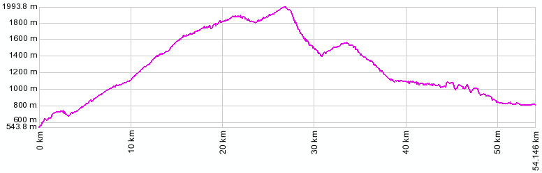
Wuerzjoch: Kiens (a few km west of Bruneck) > bike path to Vinti > Brixen > Sankt Peter > Wuerzjoch > Sankt Martin -> back to sp on bike path: 65 miles with 6400ft of climbing in 6:1hrs (VDO MC1.0 m3:9.6.27) Notes: includes some sightseeing in Brixen. . The last day with different start and end points on this Extended Tour is on page: Staller Sattel.
|
||||||||||||||||||||||||||||||||||||||||||||||||||||||
 Approaches
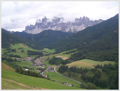
|
|
advertisement |
|
|
advertisement |