| |
| |
Carretera de la Chaba
s(u)
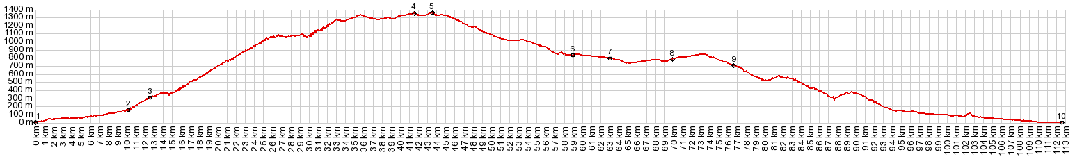
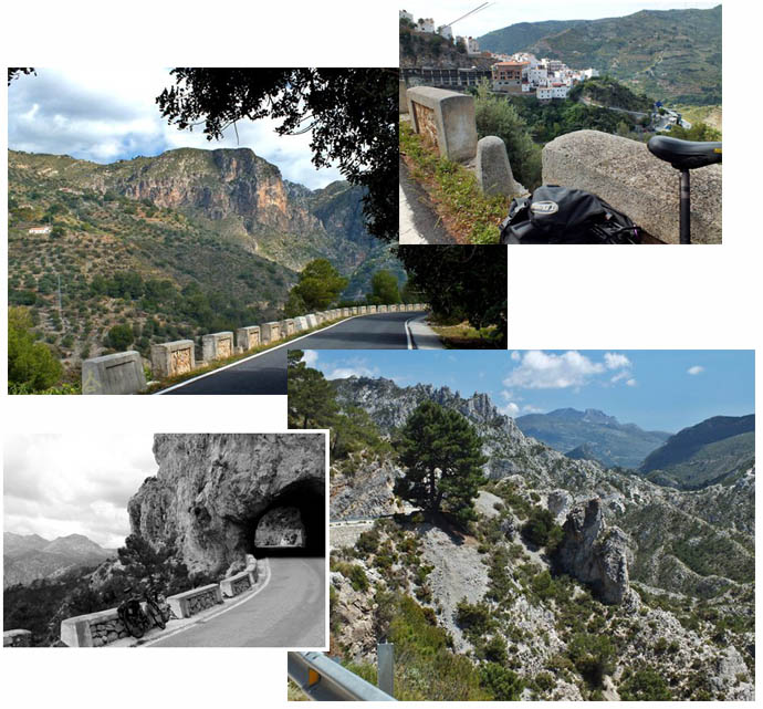
This Carretera goes up the strike
slope of a great limestone escarpment from the
Mediterranean side, and then continues over a high
plain dip slope going down to the base of the snow
covered Sierra Madre - very impressive. Everybody I talk to seems to refer
to this road as Puerto de (la) Chaba. But nobody
can pinpoint where exactly this point is. And when
I look on the map, I can't find a Carretera de la
Chaba or a Puerto de la Chaba. But informational
signs along the road label it the "Carretera de la
Chaba". Quaeldich.de lists several points along
the road as destination bicycle summits. But none
of them are the actual highest point on the road.
This one is.
By the time the road reaches Otivar, it becomes
evident that these people have to worry much more
about land and mudslides. Some of the buildings
seem to stand on stilts, just for the privilege of
doing business next to the main highway. The
supermarket here requires no detour. From here this alpine highway winds back and
forth, heading for a few limestone pinnacles,
avoiding others, seemingly trying out a variety of
view points on yet others. It is difficult to
guess exactly where this pass is. The first goal
identified by other web sites is the Mirador
Chabra de Montes. But much of the best scenery
comes after that. The road passes another
intermediate high point and skirts along several
limestone cliffs, then passes several bars or
other public establishments. This is the end of
the spectacular scenery for now. From here on the
road runs straight or with slight curves over a
high plateau, and the pavement is much rougher.
The mountains in the distance seem to float above
it all, with no apparent transition zone. The
actual high point is a small ravine with no views
in either direction. Without an altimeter you
would never guess.
From North (described
downwards). The mighty escarpment of the
Sierra Nevada comes into view, topped either with
clouds or snow. Fruit trees, planted in a square
grid pattern recede in straight lines towards the
mountains. Now the road becomes wider and smoothly
paved, and starts a straight fast descend to just
south of the the Puerto de los Suspiros Moros.
Tourist literature has it, that this was the route
taken by the Moors, when they gave up the Alhambra
and fled to Africa.
Dayride with this point as highest summit: COMPLETELY PAVED: ( < Venta
La Nades | Mirador
Cabra Montes(sh) > )
|
|
|
advertisement |
|
|
advertisement |