| |
| |
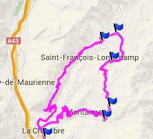
Village du Loop - Longchamp
s(u)
This summit traverses the ridge to the west of the road from La Chambre to Col de la Madeleine. There is a substantial unpaved part. You could also use this route to get to the Col de la Madeleine in an ultra quiet , sneaky way, away from all the motorcycles and skiing condos. But you do get a good view of all of them from above.
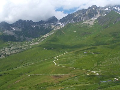
The path quickly climbs above treeline amidst a
flurry of different wild flowers, ringing cows and
the various structures needed to maintain these
bells, along with the cows that have to carry
these overweight musical monsters around. The road
now winds around small undulations of a giant
inclined wavy plain, heading straight for Col de
Madeleine.
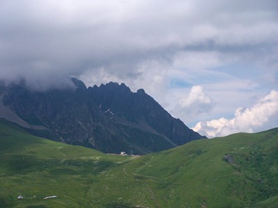
Eventually the path crosses a hill and the
viewshed changes to the skiing towers of
Longchamp. Col de
Madaleine lies across the tundra at eye
level. The restaurant at its summit lies in a
perfect shot line. There are various rough ways
down towards Longchamp. But staying on this smooth
civilized dirt road, the road engages in one more
very short climb and then goes to meet the paved
road up to Col de Madeleine, in safe distance
above the skiing commerce of Longchamp.
From North. (described
downwards) You could take the main road back down
to La Chambre. But I think the mapped route down a
side road on the west side is much nicer. It is
definitely quieter. Entering Longchamps, the key
is to not follow signs for La Chambre but for
Montgellafrey instead. This leads onto a steep,
now completely paved descent, mostly through the
trees. But once in a while a large 100 yard window
opens up onto the wall on the other side,
disappearing in the clouds above. An especially
memorable section is where the road crosses what
appears to be an active rockslide area, with a
large drop off.
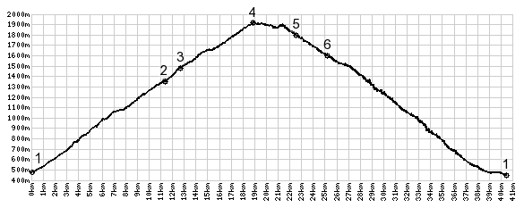
Dayride with this point as highest summit: PARTIALLY PAVED / UNPAVED Village du Loop - Longchamp s(u) , Col du Chaussy ,
additional out and back : Jt Jean Maurienne
> up D77 > Montvernier > Montpascal >
Col du Chaussy > Bonvillard > Village du
Loop > Village du Loop - Longchamp s(u) >
jct with D213 <> out and back to top of Col
de Madeleine > down D76 > Montgellafrey >
La Chambre > back to starting point: 45.8miles
with 6510ft of climbing in 5:03hrs (VDO MC1.0
m4:14.6.24). The last day on this tour with different start
and end points over a pass is: Col de Mont Cenis
|
|
|
advertisement |
|
|
advertisement |