| |
| |
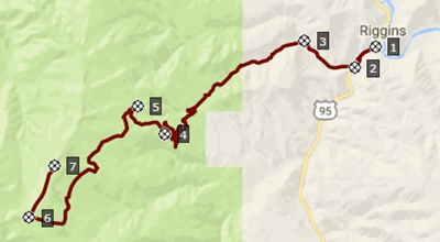
FR487 Squaw Creek Rd -
Seven Devils Rd
The Seven Devils Road is a one way
climb to a high lookout over the Hell's Canyon
area. It starts almost at the same point as the
road following the Salmon River into its maze of
canyons, that once confused Lewis and Clark. The
Salmon River Road receives many visitors, but they
have a large area to get lost in. In a
neighborhood of such scenic prominence this
Lookout is often overlooked. But these pages are organized
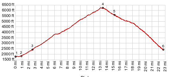
primarily by two way summits. Two bikable forest
routes can be used as alternatives for the lower
part of the Seven Devils Road. These two
alternatives form a two way summit and are shown
in the first profile. The one way climb is below
that.
At point 2 the Seven Devils Rd makes a 90 degree
left turn. But the profile just keeps going
straight, and is now on FR487 the Squaw Creek Rd.
On a climb to the one way summit, this option
bypasses all of the heavy gravel on the
intermediate part of the Seven Devils Rd, and is
much more bike friendly. After a good workout the
road enters National Forest land and passes a gate
which closes the road to motorized traffic. The
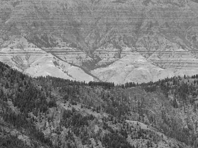
grassy canyon sides carved by the Little Salmon
River appear as backdrop between wildflowers and
dense trees. This is a very bikable road with an
extremely smooth surface. After many switchbacks
the road crests in the forest. SLIDESHOW1: bottom to Windy Saddle
From East-2. And from
here you can already see the FR487 joining the
Seven Devils Rd again. The profile turns left and
rolls back down, to meet the first FR487 junction,
this time with more gravel than on the East-1
approach.
Uphill from this junction the road surface is
remarkably smooth again, much better than going
down from here on the Seven Devils Rd. The road
quickly reaches a few scree slopes, that open up
great views on the mountains to the east. During
my July 4th 2017 ride, remnants of snow outlined a
few rounded peaks above treeline in the distance. The route reaches what at first looks like a pass
because of the change of viewsheds. The devil
theme figures prominently in the naming of
surrounding land features. But the road continues
to climb after the change in viewsheds. A named
pass comes a little later: Windy Saddle. The other
side of the saddle has a trail approach. But it
reaches into the wilderness area and does not
descend 500ft before climbing again. From here a short spectacular spur leads through
a stick forest of dead trees, that make infinitely
many photo foregrounds possible. It only lasts .7
miles and ends at a parking lot below an old fire
lookout. The last .2 miles are reserved for foot
travel. Pictures from this last section on foot
are included in the slide show. The walk only
takes 10 minutes.
PARTIALLY PAVED / UNPAVED ( < Banner
Summit | FR2028
Skookumchuck Rd(sh) > ) SLIDESHOW 2: from Windy Saddle to Devil's
Lookout
|
 Sidetrip to Seven
Devils Lookout: The real attraction of this
climb is this out and back climb to a Lookout
Point over the Hell's Canyon area, from where you
can make out geographical features belonging to
four states.
Sidetrip to Seven
Devils Lookout: The real attraction of this
climb is this out and back climb to a Lookout
Point over the Hell's Canyon area, from where you
can make out geographical features belonging to
four states.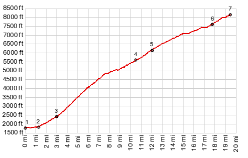
 Dayride with this
point as highest summit:
Dayride with this
point as highest summit:|
|
advertisement |
|
|
advertisement |