| |
| |
FR595 Lolo Pass - Granite Pass This summit is the answer to
the question: "What does the scenery on
Lolo Pass look like ?". In far less time
than it would take to get me, to get a
drone into operational condition, a bike
ride from here will answer this question.
Directly across from the Lolo
Pass parking lot a narrow road climbs north,
in order to meet FR595. FR595 itself off
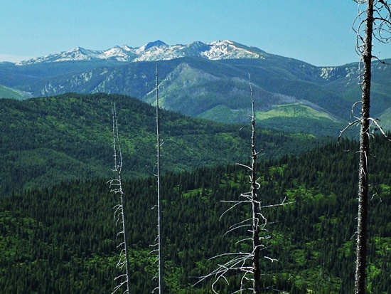
US12, a few hundred yards further east. The road climbs steeply and
thanks to the logging industry, a far
reaching view opens up quickly. There are
islands of peaks poking above treeline all
around,with a sea of rolling green hills in
between. The road itself crests in the
forest at a turnoff to FR5672. I went down
this way, looking first for a loop,
direction south of here. I did not find a
through going route. But this was a
extraordinarily hot day, and the question if
such a route exists, is still open, as far
as I am concerned. FR5672 forks again after
a while into FR5643. Both of these forks
take on an "abandoned road" character after
a while. According to the map they end
completely. But FR5672 has a greater than
500ft elevation gain, so that I count this
as a summit if approached from there. 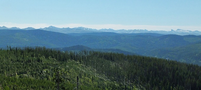
From
North. (described downwards) Along
the traverse and descend to Granite Pass
good views persist. Granite Pass itself is a
generic place in the forest, without
distinguishing natural characteristics, much
like Lolo Pass. There is a pass sign
however. The roads, crossing at this
intersection, are well signed. The option
continuing west to various creeks is said to
end after a long distance. I feel, that for
me at this point and time, there are no
further scenic incentives visible to
investigate this question further. Besides
it's July and only getting hotter with lower
elevations (that's actually the real
reason). The profile heads lower south
on FR9942 which is also well signed. This
road stays in a low, generic forested
valley. The road surface can be a little
difficult to predict in a downward
direction. But luckily I managed to stay on
the bike at all times. One more right turn
at a T intersection leads back to US12, the
starting point of the other approach.
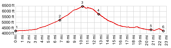
 Dayride with this point as highest summit: ( < Brushy Fork - Spruce Creek Divide | Marias Pass > ) FR595 Lolo Pass - Granite Pass x2 : a short distance from Lolo Pass on FR373 Spruce Creek Rd > down FR373 > Lolo Pass(shp) > up FR595 > FR595 Lolo Pass - Granite Pass <> out and back on FR5672 until it becomes passable only with difficulty <> separate out and back on FR5643 until it becomes passable only with difficulty >> Lolo Pass a second time > FR595 north > Granite Pass(shp) > FR9942 east > Fish Creek Rd > Lolo Creek Rd south > U12 west > Lolo Pass(shp) > back to starting point on FR373: 36.7miles with 3970ft of climbing in 4:42hrs (garmin etrex30 m3:20.7.25) Notes: I met two gravel bikers on this loop - first biker encounter on this entire trip. |
|
|
advertisement |
|
|
advertisement |