| |
| |
White Bird Hill Rd s(u)
The road leaves behind the scenic
river and crosses this big grassy ridge, heading
as straight as possible for Grangeville. The
result is White Bird Hill. There are two of them,
this one and an "Old White
Bird Hill" route. The latter is a much more
attractiive route, especially on a bicycle. Both of these routes encircle a
historic battle field, the first first battle
between the Nez Perce Indians and the US army. The
name White Bird derives from and Indian name in
that context.
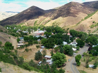
From South. (also
described upwards) The road climbs a small amount
above the Salmon River and after a small descent,
crosses White Bird Creek on a bridge, high enough
to give a bird's view of the town White Bird. In
order to get there and its small grocery store you
have to detour onto Old US95. The rest of the climb is quickly described: a
single straight, uniform cut, traversing up he
hillside. The views are great, the road is boring.
Supermarket parking lot sized turnouts lead to
small signs, containing 2 or 3 sentences with
interesting facts, or simply designed to provoke
interest in the area. One of these is a strategic
vantage point onto the White Bird battlefield and
the various positions held by Indians and
soldiers. The Old White Bird Hill road merges onto today's
US95 a few hundred feet below the summit, but then
leaves it again to climb to a higher point.
Immediately before the summit of the new road,
another large parking lot, lined with flagstones,
invites to what is probably the most panoramic
view along the new road. Shortly after that the
road summits in the forest with a sign saying
4245ft. But according to my gps, the summit is
clearly a little higher.
A Dayride with this point as intermediate
summit is on page: Banner Ridge Rd
s(u)
Historical Notes: The Highway: This road grade replaced the Old White Bird Hill Grade as recently as 1975. For more see the Old White Bird Hill s(u) page. |
 US95 manages to follow
along the bottom of the Salmon River Canyon for
many spectacular miles. But then, about 20
miles south of Grangeville, the canyon becomes too
narrow, and the road is forced on a detour over
the Clearwater mountains.
US95 manages to follow
along the bottom of the Salmon River Canyon for
many spectacular miles. But then, about 20
miles south of Grangeville, the canyon becomes too
narrow, and the road is forced on a detour over
the Clearwater mountains.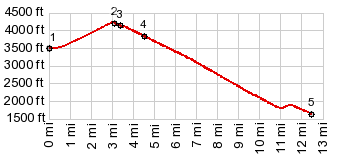
|
|
advertisement |
|
|
advertisement |