| |
| |
FR290 shoulder summit:
Broomtail Ridge
The road running along the top of
the Gravelly Range is too long for a comfortable
day ride in its entirety. But several access point
allow splitting the road into sections that can be
ridden in a day without superhuman effort. This
northern portion of the Gravelly Range Road does
not quite reach the altitude of the road south of
here. Therefore it's described here as a shoulder
summit.
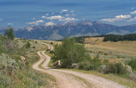
From South. During summer the turnoff to
McAttee Bridge from US287 is almost as big and
busy as a freeway interchange. Most of the traffic
is fishing traffic. The road remains hard-medalled
and extremely wide as it climbs into the benches
of the Madison River. Soon the reason becomes
obvious, this is the access road for a talc mine.
The industrial strength road goes past the mine
main entrance, and sweeps south over the benches
in wide turns, creating the first majestic views
of the almost treeless, but nontheless green
valley below. While the wide road continues to a
second mine entrance at its top, a clearly marked
fork diverts to the left and starts to climb a bit
more steeply. When this road enters the forest it
has already gained a respectable amount of
elevation, what seems like a third of the way up
the peaks of the Gallatin Range across the valley.
The road surface is good for climbing. At the
junction with Johnny Gulch, Johnny Ridge Road
switches back to the south and traverses up the
Gravelly Range in one long straight away. A wide
turn circles around a stately tree, that has been
reduced to a paper cutout by the bark beetle
epidemic. What follows is the first panoramic view
of the Madison Range. On the ridge the trees give
way to wide stretches of tundra, lined by
carcasses of dead trees. Johnny Ridge Road merges
onto FR290. To the left will lead to the highest
point on the Gravelly Range Road (described as
FR290 Monument Ridge summit(u). The option
described here stays right and almost
imperceptibly climaxes on the next stretch of
tundra. The Beaverhead National Forest map labels
the spot as Broomtail Ridge, but the name is not
found on any of the numerous signs at
intersections. The summit is higher than the
junction Johnny Ridge Road - Gravelly Range Road.
But the climb is less than 300 foot, so I'll call
this a shoulder summit.
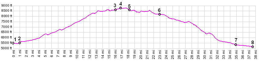
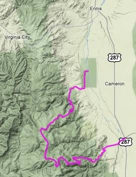
From North. (described downwards). There is a fleeting view of the Greenhorn Range to the west, but the ride takes on more and more of a plateau character, until the route turns right off FR290 onto FR292 and descends onto Call Creek Road. This last part of FR290 is also more heavily graveled. The turnoff is clearly marked, and staying on FR290 would involve opening a gate. A fast descend leads to more groves of dead trees. They mark the transition from national forest land to private land to the many widely scattered houses south of Enis. The road becomes a steep, heavily graveled descend, that would be difficult to climb. But views of peaks in the Madison Range across the valley compensate for this little inconvenience. The group of three peaks Sphinx Mtn, Black Mtn and the Helmet look like glaciated horms from one direction and resemble a broken ridge from another. The profile turns right to rickety old Varney Bridge and reaches a low point crossing the Madison. Dayride jct US287 - Mc Attee Bridge, partially up FR324 > up FR324 Johnny Ridge Road > FR290 shoulder summit: Broomtail Ridge > down FR292 Call Creek Road > Varney Bridge > south on US287 back to starting point: 53 miles with 4400ft of climbing in 5:1 hours. There is also a shorter, rough dirt road option that stays west of the Madison. (VDO) MC1.0 m3:10.8.16). |
 Approaches