| |
| |
FR290 summit(u): Monument
Ridge
 When traveling up the Madison
River Valley between Enis and Raynolds Pass, you
can't help from being distracted by the left side
of the road - the far left side, the Madison Range
and all its straight alpine lines, sitting over a
carpet of green. The view towards the right is
less interesting. That would be the Gravelly Range
on the west side of the valley. It looks more like
your average collection of forested hills from
this particular vantage point. But the Gravelly
Range has other advantages. For one, it has roads
going up towards its summits. These roads are
located not just across from the Madison Range,
but also another picturesque mountain group, that
just cries out for a perfect viewing point, and
the Gravelly Range is that point. Also, many (but
not all) of these roads have a smooth surface with
really very little gravel, despite the name. The
ride is also relatively peaceful due to a lack of
ATV trails in the area. When traveling up the Madison
River Valley between Enis and Raynolds Pass, you
can't help from being distracted by the left side
of the road - the far left side, the Madison Range
and all its straight alpine lines, sitting over a
carpet of green. The view towards the right is
less interesting. That would be the Gravelly Range
on the west side of the valley. It looks more like
your average collection of forested hills from
this particular vantage point. But the Gravelly
Range has other advantages. For one, it has roads
going up towards its summits. These roads are
located not just across from the Madison Range,
but also another picturesque mountain group, that
just cries out for a perfect viewing point, and
the Gravelly Range is that point. Also, many (but
not all) of these roads have a smooth surface with
really very little gravel, despite the name. The
ride is also relatively peaceful due to a lack of
ATV trails in the area. I probably should have started
the last paragraph with the simple observation:
This is my favorite bike ride in Montana so far.
Granted I am biased, I had excellent, cool weather
after a prior, raging heat wave. I have been told
by other visitors of the area that commercial
touring companies lead mountain bikers up here. I
am not sure why this should make the area seem
more (or less) attractive, but apparently I am not
the only one who likes this ride. But it's safe to
say there aren't that many who have tried it out.
The fishermen outnumber cyclists by at least a
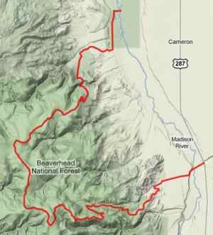
million to one. This is a well signed route with
little chance to get lost. Still - the
"Bearverhead National Forest - southern part" map
is the perfect companion for all the route numbers
and landmarks along the way.
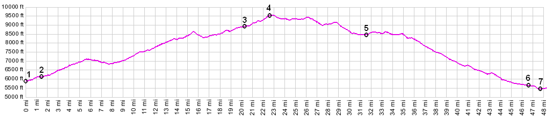
Approaches From South. There are two Lyons bridges
across the Madison River. One is a modern bridge
at the Highway Rest area. The profile starts at
the other one, a lovely old rickety bridge that is
still good for four tons. Once on the other side,
FR209 stays uphill of the river. The road directly
adjacent to the river is filled with fly
fishermen, sometimes so many it's a wonder their
flies don't get tangled into each other. Soon
FR237 forks to the right into the hills. It has a
smooth surface and very little traffic.
Both sides of the road seem to compete for views,
and it's pretty near impossible to come up with a
favorite. In the Madison Range a glaciated horn
becomes more clearly visible as the road
progresses, while on the left, the late afternoon
light makes the Greenhorn Range stand out with
more shadows. There is more traffic on this part
of the road (not a lot - but more than none), and
the surface also has a hint of gravel, but nothing
that I would call gravelly. The route takes on
more of a plateau character, as it passes Clover
Meadows campground. Shortly thereafter, the route
described here, leaves the main ridge by turning
right down Johnny Ridge. As the descent approaches
timber line, the same dead tree spectacle from the
ascent repeats in reverse. Finally trees obscure
the majestic Madison Range views and a long, fast
downhill traverse through the trees, leads to the
junction with Madison Gulch, and onward,
terminating - surprise - at a mining operation. Mc Attee Bridge is used to cross the Madison
River and get ack to the paved road. It carries
much more water than upstream where the ride
started. There is a secondary road on the west
side of the river that also looks like an
alternative to return to the starting point. But
it dead ends. The profile ends at the bridge, but
if traveling back to the starting point north on
US287, the shoulder is really not bad, but it is
rumble stripped as is common in Montana. The space
to the right of the strips is adequate for riding,
but not spacious. Dayride with this point as highest summit: |
 On my traversal of the route on a
Sunday in July I saw no vehicles of any kind
before the junction with FR290 Gravelly Road. A
number of curvy climbs lead through forested
hills. They open slightly and the Madison Range
across the valley begin to take on a new character
through the trees. A shallow downhill leads into
the Standard Creek drainage. After a long climb
the Gravelly Range itself starts to take on a
rocky character, first when approaching the
Wolverine trailhead. The road becomes less
traveled. Less traveled may be the wrong word,
since I already encountered no vehicles up to this
point - a little narrower and a more tenuous road
bed then. The road drops a few feet but then
climbs again between two small sedimentary rock
outcrops resembling cake layers. Black Butte comes
into sight, the shape of a crowning gable on a
roof of green. Another road comes up from the
south side, and the road I am traveling (FR237)
gives up its number to it. The journey now
continues right up FR290, Gravelly Range Road.
Passing through a grove of horribly, yet
picturesquely dead trees, the road takes leave
from trees in general and keeps on climbing.
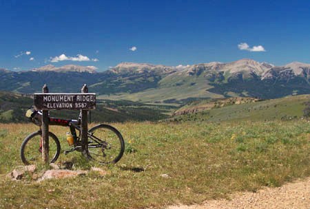
Turning left into irregular switchbacks, a great
scenic surprise waits on the other side. The
Greenhorn Range doesn't make it into any Montana
travel guides that I know of, yet from this
vantage point it's a very scenic view indeed, a
range composed of ramps that crest into a
harmonious grand landscape. On top is a sign
stating "Monument Ridge", together with the
elevation.
On my traversal of the route on a
Sunday in July I saw no vehicles of any kind
before the junction with FR290 Gravelly Road. A
number of curvy climbs lead through forested
hills. They open slightly and the Madison Range
across the valley begin to take on a new character
through the trees. A shallow downhill leads into
the Standard Creek drainage. After a long climb
the Gravelly Range itself starts to take on a
rocky character, first when approaching the
Wolverine trailhead. The road becomes less
traveled. Less traveled may be the wrong word,
since I already encountered no vehicles up to this
point - a little narrower and a more tenuous road
bed then. The road drops a few feet but then
climbs again between two small sedimentary rock
outcrops resembling cake layers. Black Butte comes
into sight, the shape of a crowning gable on a
roof of green. Another road comes up from the
south side, and the road I am traveling (FR237)
gives up its number to it. The journey now
continues right up FR290, Gravelly Range Road.
Passing through a grove of horribly, yet
picturesquely dead trees, the road takes leave
from trees in general and keeps on climbing.
Turning left into irregular switchbacks, a great
scenic surprise waits on the other side. The
Greenhorn Range doesn't make it into any Montana
travel guides that I know of, yet from this
vantage point it's a very scenic view indeed, a
range composed of ramps that crest into a
harmonious grand landscape. On top is a sign
stating "Monument Ridge", together with the
elevation.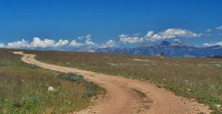 From North. (described
downwards). The picture above was taken at the
point of highest elevation. But from here it's far
from downhill all the way. Instead a long traverse
follows with many minor ups and downs along the
ridge top, and the route is obvious. From the
summit a white ribbon cuts across the green ridge
ahead, interrupted many times by folds in the
landscape, surrounded by small dots that turn out
to be trees - the road ahead.
From North. (described
downwards). The picture above was taken at the
point of highest elevation. But from here it's far
from downhill all the way. Instead a long traverse
follows with many minor ups and downs along the
ridge top, and the route is obvious. From the
summit a white ribbon cuts across the green ridge
ahead, interrupted many times by folds in the
landscape, surrounded by small dots that turn out
to be trees - the road ahead.