| |
| |
Priest Pass In this area of the
continental divide, you have the choice of
two dirt road crossings: Priest Pass and Mullan Pass,
as well as a stinky four lane highway: Mac
Donald Pass. Priest Pass is in
between the two others, in distance and in
physical location. Obviousely - and I
don't use this word lightly - this is a
great place for pass loop rides. But maybe
I am using the word needlessly,
obviousely. Maybe the word "obviousely" is
of limited usefulness ...
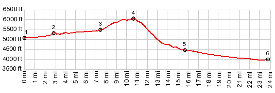
From
East. (described downwards). Its a
fast decent through trees - no real reason
to stop, until the road meets up with US12
between Mac Donald Pass and Helena. The
profile includes the shallow decent on a
four lane paved road to the outskirts of
that pleasant small city/town that happens
to be the Montana capitol
 A Dayride with this point as intermediate summit is on page: MacDonald Pass  History HistoryPriest Pass was meant as competition to nearby MacDonald Pass, today's US12. Valentine Priest had previously had trouble with Tuberculosis and settled in Grizzly Gulch, near Helena in the late 1870s. For a while he managed the MacDonald Tole Road for Old MacDonald, and in the late 1870s he decided that he could do better himself. The result, Priest Pass, was easier and 300ft lower. During the beginning of the motoring age, when Model T's roamed the west, both passes were popular automobile routes, with Priest Pass being the primary crossing. This remained until well into the socalled "motoring age", until policies began to favor a modern road cutting through the landscape like a machete over today's MacDonald Pass |
|
|
advertisement |
|
|
advertisement |