| |
| advertisement |
| -------- |
| advertisement |
|
Emory Pass
 Emory
Pass is not the highest or the steepest pass
in New Mexico. Neither does the road have a
shoulder of any kind. But because of a
number of factors, this is my favorite paved
pass or summit in New Mexico so far. For one
thing it doesn't need a shoulder. Traffic is
so light (at least in winter) that a
wider road would only disturb the landscape
more needlessly. The surface is a rough chip
seal. But currently it has matured and is so
smooth that it is perfect to ride on with
any kind of skinny tire (Feb 08). The road
is in strong contrast to the area to the the
south. Coming up from the Mexican border and
Deming there is an amazing absence of
garbage and litter. It almost seems, that
you have crossed into a different country
again. Neither are there those annoying
tourist businesses that sell junk of all
kinds. The contrast in landscape is also
amazing. After the stark shapes in the
dessert to the south, the road climbs into
deep soothing forest. These mountains are
part of the basin and range province. The
ranges are individual fault blocks with a
younger geology than superficially similar
landscapes, like all those rounded hills in
the Appalachians for example. Here the
landscape has a more angular, disturbed,
look. Finally, unlike many of the forested
paved climbs in the Sangre de Cristos to the
north, there is a grand overlook onto the
drier dessert mountains to the east. All
this - and you can make believe it is the
season of your choice during mid February. Emory
Pass is not the highest or the steepest pass
in New Mexico. Neither does the road have a
shoulder of any kind. But because of a
number of factors, this is my favorite paved
pass or summit in New Mexico so far. For one
thing it doesn't need a shoulder. Traffic is
so light (at least in winter) that a
wider road would only disturb the landscape
more needlessly. The surface is a rough chip
seal. But currently it has matured and is so
smooth that it is perfect to ride on with
any kind of skinny tire (Feb 08). The road
is in strong contrast to the area to the the
south. Coming up from the Mexican border and
Deming there is an amazing absence of
garbage and litter. It almost seems, that
you have crossed into a different country
again. Neither are there those annoying
tourist businesses that sell junk of all
kinds. The contrast in landscape is also
amazing. After the stark shapes in the
dessert to the south, the road climbs into
deep soothing forest. These mountains are
part of the basin and range province. The
ranges are individual fault blocks with a
younger geology than superficially similar
landscapes, like all those rounded hills in
the Appalachians for example. Here the
landscape has a more angular, disturbed,
look. Finally, unlike many of the forested
paved climbs in the Sangre de Cristos to the
north, there is a grand overlook onto the
drier dessert mountains to the east. All
this - and you can make believe it is the
season of your choice during mid February.
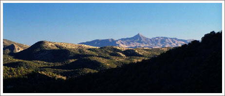
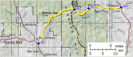
Approaches From West. The lower approach on NM61
following the Mimbres River below the starting
point on the profile is a pleasant ride
through large gently flowing hills, passing
settlements that have names on maps, despite
the fact that they consist of a few
interesting old houses or lived in schoolbuses
and a white church here or there, services
every other Saturday. It's a great ride in mid
February, but I imagine it gets pretty hot
during most of the year. The profile starts
with Ancheta Canyon after the junction
NM90-NM6. The road soon climbs into a juniper
forest with interesting views back down into
the Mimbres Valley. Instead of climbing the
high ridge ahead the road turns right and
crests on an intermediate summit in order to
descend back down to the lower Gallinas area.
The road rounds a deep ruggedly incised
meander of this creek and climbs in deep
forest towards the ridge line. The last miles
are comprised of forested switchbacks in order
to deliver the rider at a grand overview of
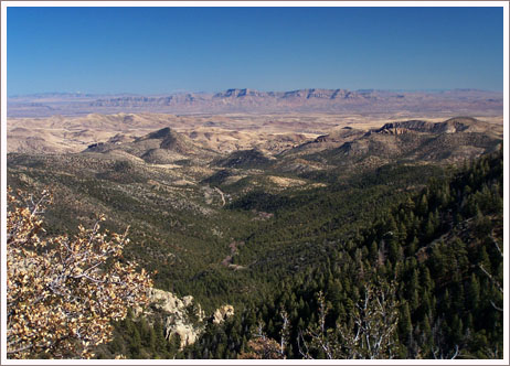
the Rio Grande Valley to the east. The
overlook is few feet higher than the pass and
the far views come as a great surprise after
climbing into heavier and heavier forest.
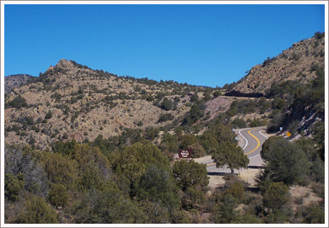
From East. (described
upwards) The open lava capped valleys of the
Rio Grande tributaries seem to end in the old
mining town of Kingston. The town contains
only a few buildings that show little sign of
life, and instead add to the feeling of
remoteness of this area. Above lies a forested
climb up a traverse, where the road is never
straight but follows every contour of the
land, great cycling. Looking back you can
often see the road turns stack up behind one
another, similar to the contours of a relaxed
snake that is maybe in the process of crossing
a road. Now and then you catch a glimpse of
the dessert hills below. Some of the upper
turns are perpetually shaded and remnants of
snow linger long after the last storm.
Tours Dayrides. An out and back ride starting at the junction
of NM90 and NM61, over the pass to a
turnaround point a mileage marker 45, about 5
miles shy of Hillsboro measured 63 miles and
6000ft of climbing in 5:2 hours measured with
a Vetta cyclecomputer (with some tire
problems) (r2:08.02.07).
back
to New Mexico's Summits and Passes by
Bicycle |