| |
| advertisement |
| -------- |
| advertisement |
|
Lagunita Saddle
 Lagunita Saddle is never going to make it
into the top 10 list of favorite New Mexico
MTB rides, and that in spite of its
impressive altitude gain. Instead MTB guide
books focus on a number of short rides on
the east side of this flat saddle. The
saddle is marked in these books. For those
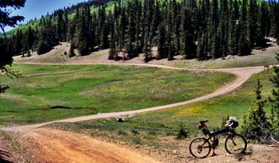
not afraid of gravel, the ride from the
bottom is quite a workout ride through a
forested canyon. An additional 200
feet has to be climbed over the ridge
separating the saddle from the Red River
valley in a loop ride.
Lagunita Saddle is never going to make it
into the top 10 list of favorite New Mexico
MTB rides, and that in spite of its
impressive altitude gain. Instead MTB guide
books focus on a number of short rides on
the east side of this flat saddle. The
saddle is marked in these books. For those
not afraid of gravel, the ride from the
bottom is quite a workout ride through a
forested canyon. An additional 200
feet has to be climbed over the ridge
separating the saddle from the Red River
valley in a loop ride.
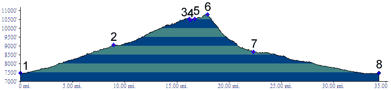
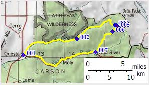
Approaches From East. The Cabresto Canyon road leaves from Questa, roughly paralleling Red River Valley, and soon turns into a gravel road, that is not the easiest to ride. The top is a subalpine meadow. Road conditions improve considerably approaching the top (May/05). From South. Continuing over the
top, a confusing number of forest roads make
route finding difficult on the first go around.
The first sign after the unmarked top
points the way to the (Midnight) Trail Canyon
jeep road. The descent is often too steep and
rocky for staying on the bike. Dayrides. A ride from Questa over the saddle and
descending the route outlined, continuing back
to Questa through Red River valley, measured
60 miles with 6130 feet of climbing. This
includes around 5 miles of route finding on
the east and south sides of Lagunita Saddle.
The eastern approach of the saddle is also
included in the route over Ortiz
Peak summit(u).
back
to New Mexico's Summits and Passes by
Bicycle |