| |
| advertisement |
| -------- |
| advertisement |
|
Manning
Canyon summit(u)
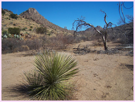
The Tres Hermanas Mountains
(Three Sisters) are a series of bold rock
outcrops in New Mexico just north of the
Mexican border. If the dessert has the
sweeping quality of an ocean here, these
mountains are like small islands in this
tranquil sea. The higher Florida Mountains
to the north have a more direct visual
appeal, but it's easier to get a bike
through the rock outcrops of the Tres
Hermanas. This is a great little ride in mid
February, which is ecspecially great fun
when the news is dominated by snow storms in
the Rockies, and north eastern blizzards.
There is guaranteed no snow in this corner
of New Mexico. Instead it's a fascinating
landscape comprised of prickly pear cacti,
Ocotillos, statue like trees and other
hearty plants. Except for the initial
turnoff, there are no signs of any type
along the route. The name of the summit is
derived from a label in the "Roads of New
Mexico" atlas published by Shearer
Publishing.
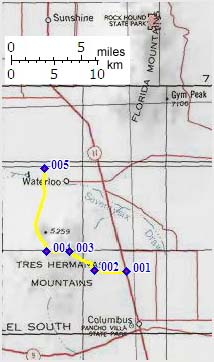
From East. The dirt road turnoff from
NM11 to this summit is opposite an old
development that was to become a private air
park hacienda (picture in photo page). Now
signs advertise the sprawling arched motel
walkways as the land of opportunity, which is
for sale. The turnoff to Lauterner Lane is a
few hundred yards north of the entrance to the
old air park. You can't miss the entrance to
the old air park. Looking through it you see a
replica of an old plane used to chase Pancho
Villa back into Mexico perched as foreground
to the Florida Mountains. Lauterner Lane heads gently up an expansive
alluvial fan to the foot of the Tres Hermanas
Mountains. As the main traffic on this road
makes a right hand turn to two private homes,
the route continues straight. A few hundred
yards before the end of the road a double
track trail takes off to the right. It heads
north along a fence line, surrounded by a
surrealistic plantscape of cactuses and ito
plants. The route crosses a fenced gate,
trending westwards again, and then heads in
the general direction of the highest peak in
the Tres Hermanas. After another gate is
crossed a right fork followed by a left fork
(or possibly the reverse) heads into a canyon
flanking the most prominent peak. A short
climb into the shallow canyon leads to another
left fork that climbs the summit in one short
swell foop (or fell swoop). From this last
fork you can see another less traveled trail
that climbs a summit to the south at about the
same altitude, and also a prominent trail that
climbs a shoulder of the highest peak to the
north. The route on the north side ends at the
saddle, even though that is not apparent from
this vantage point. The short stretch to the
summit followed here is quite rocky and
necessitates some walking.
From West. (described downwards).
There hardly seems to be a descent at all from
these low rocky outcrops back down to the
dessert. The route enters an arroyo for only a
short time and then crosses a plethora of
other tracks. The general idea is to head
north and down the alluvial fan, which
necessitates a number of right and left turns
at forks. Best just to budget a little extra
time. The route exits onto a county road
through a fenced gate, where there is also a
fenced parking lot of sorts. From here one can
go back to the Columbus-Demming road or head
west direction Tres Hermanas Grade road, where
a stationary unmanned blimp is waiting to
photograph illegal aliens, coming across from
Mexico. The blimp also makes a good
orientation point, and also sometimes
misidentifies mountain bikers as illegal
aliens ( for example me ), since illegal
aliens are a lot more common than cyclists in
this general area. When riding alone this has
the advantage of a possible rescue by border
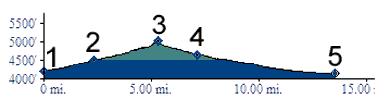
patrol in case of emergency. Tours Dayrides. A loop ride with a few extra
out and backs was as follows: Columbus >
Manning Canyon summit(u) > around the north
side Tres Hermanas mtns to NM11 >
back to Columbus. The mileage and time
includes around 5 extra miles of checking
possible routes on the west side of the summit
and about 10 miles of unrelated mileage trying
to find a bikable route around the south side
of the Florida Mountains: 50 miles with 1500ft
of climbing in 4:5 hours, measured with a VDO
MC1.0 cycle computer.
back
to New Mexico's Summits and Passes by
Bicycle |
 Approaches