| |
| |
Boulder City(sh)
Boulder Citys all over the United
States seem to be great cycling destinations,
weather in Colorado, New Mexico or Nevada. This
one is in Nevada. The most excellent "River
Mountains Loop Trail" (confusing name - but it's a
trail making a loop, follow mountains named
"River Mountains"), a meticulously paved bike
path, as wide as a regular French, road crests
here. But curiosity would also dictate a ride
through the old historic center of Boulder City,
and a direct route through Boulder bypasses the
summit on the bike path, and substitutes the one
profiled here. Of course you could ride the bike
path and ride out and back to the town center. Be
that as it may, this is the highest point of a
direct approach to the Old Historic Boulder City
center.
From North. From the
summit, old downtown recedes downhill in a
southerly direction. On weekends the town is well
walked by tourists, and many interesting
sculptures along the way help to entertain. They
all have a certain Norman Rockwell type quality,
and manicured well watered lawns seem to surround
all structures of good standing. The chain store
businesses and fast food joints come later on
Nv582, south of the historic part of town. The
route switches to the bike path as soon as the
path parallels Nv582 for the first time. The
summit for the bike trail is a bit higher and some
distance south of the old town, located in the
bare dessert hills. 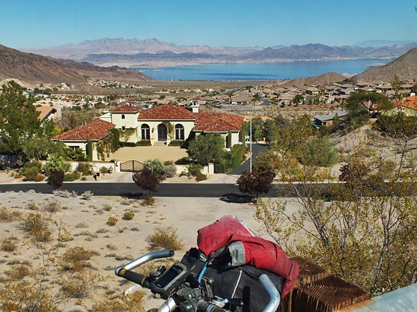 The profile follows the bike path over a shoulder
summit called Railroad Pass, with scenic view onto
gambling casino/ truck stop - all very big, but
small compared with the sign announcing it. The
bikepath follows a 4 lane highway, parallel but so
far away that you can't even imagine what the
fraffic would sound like. In the distance Sunrise
Mountain serves as orientation point and as
magnificent sculpture by nature, without a touch
of Norman Rockwell influence. Later the bikepath
detours around a water tower and an electrical
transformer facility, adding some serious rolling
hills to the route. The profile gets off the bike
path near the boundary to the Lake Mead National
Rec Area and then follows follows Lake Mead North
Shore Rd to a low point, where it crosses a wash.
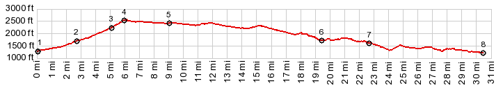
Dayride with this point as highest summit: COMPLETELY PAVED: ( < Lake Mead Blvd s(u) | Oak Springs Summit > ) Boulder City s(u) : Government Point > Government Wash Rd north > North Shore Rd south > Lake Shore Rd south <> out and back to Las Vegas Bay >> Lake Shore Rd south > River Mountains Loop Trail south > Nevada Highway south > Boulder CIty(sh) > Nv582 north to first exit <> out and back on River Mountains Loop Trail south back to Boulder City with turnaround point just past the summit >> River Mountains Loop Trail south > Henderson River Mountains Loop Trail east > North Shore Rd north > Government Wash Rd south back to starting point: 58.9miles with 4000ft of climbing in 5:28hrs (garmin etrex30 m3:19.11.2) |
|
|
advertisement |
|
|
advertisement |