| |
Luchsinger Creek Rd/
Bridge Rd(sh)
This dirt road summit
connects the paved roads in Elliot State
Forrest with the more isolated south side of
the Umpqua River. I think the most interesting
stretch is the lower southern approach, the
reason - the same as with all the roads in
this area: old jungle like forest. In case of
attempting to fit this point into a loop ride,
it would be an excellent idea to plan for the
eventuality that the bridge over Luchsinger
Creek is out.
From West. I hadn't
planned on going up this side, just coming down
it. But when the time came to cross Luchsinger
Creek and head west along the Umpqua River,
there was no bridge that would accomplish this,
as shown on the map. I was later told that the
bridge was out, and will continue to be out, due
to lack of funds. But I couldn't even find a
bridge that was "out". I couldn't find a bridge,
period. I could have headed east along Butler
Creek Road, but on my loop that would have been
an even bigger detour. So - consequently - here
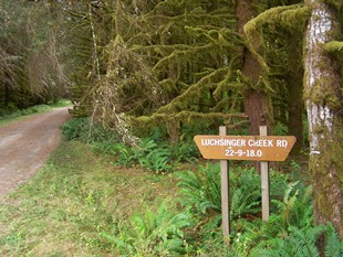
is the uphill description. Signs label both Butler Creek Road
emerging from the brambles, and Luchsinger
Creek Road, leading into deep mossy forest.
Immediately east of this junction is an
abandoned farm house and the biggest wild patch
of blackberries, that I have ever seen in my
life. I still have a stomachache as I write
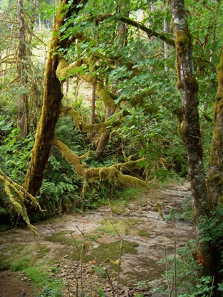
this. The Luchsinger Creek Road crosses
three small green overgrown creeks and follows
dark shadows into a tunnel of old growth
vegetation. It all ends where the road makes an
abrupt right turn (looking back you see a
Luchsinger Creek sign pointing left). From here
to the top, this is a road through logging
country, few clear cuts, many checker board
forests of varying age, some thinned forests.
Short sections of the road are heavily graveled.
Approaching the jct with Bridge Road, far views
show how much of the high area has been clear
cut. Past the junction with Bridge Road, which
gives up its name to Luchsinger Road, the path
still keeps climbing, skirting some wild forest
again. - Don't think I need to mention any more
that there is no view from the top.
From East. The descent is
a timber company road with two road barriers,
blocking motor vehicles. At the first junction
with a crossing dirt road, I went left (the most
downhill option) to meet back with paved Camp
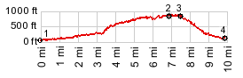
Creek Road. The profile goes all the way back to
Or38 on the Umpqua A Dayride with this summit
point as intermediate summit is on page:
Buck Creek Rd
/ Lindy Bridge Rd s(u) - |
 Approaches
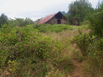
|
|
advertisement |
|
|
advertisement |