| |
| |
Bulldog Pass Rd s(u)
This is an unpaved parallel
alternative to the Ut91 Utah Hill
Summit. This is quite a bit more work due to
the gravelly nature of the surface and additional
ups and downs. It also presents a richer scenic
menu.
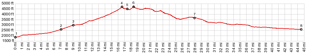
These initial miles are some of the most scenic
along the way, thanks to the pedestal like view
point on a high alluvial fan, liberally sprinkled
with Joshua Trees, and a few other cacti. The road
seems to head for two vertical rocks forming a
kind of gate in the grass covered mountains. But
right before the road gets there, it turns right
and climbs higher, past a rock climbing area and
then into higher and bleaker valleys. The power
lines and the road are heading for the same high
gap. Actually there are two high summit gaps in
succession, the second only by a few feet higher.
They are separated by a 300ft drop, with a turnoff
at the bottom between the two, leading another
200ft or more lower. Hence they are separate
summit points. The first one (lower only by a few
feet) is designated Bulldog Pass on the map. There
are no signs at either summit point. All the power
lines at Bulldog Pass give the place an industrial
look. The second summit point opens up the first
unobstructed view to the Pine Valley Mountains and
the grand gelologic straircase that starts behind
St George. I'm calling that one Bulldog Pass Rd
s(u).
From North. (described
downwards). After the first downhill an unsigned
intersection presents a question: Which one to
take ? I stayed left, which is the fastest way to
get back to Ut91. Both options also present an
uphill section next. While turning in a westerly
direction, the view takes in a new pink geologic
formation (Bryce Formation?) as foreground to the
color coded cliffs in all directions. The final
section back to Ut91 is uphill in side the
Shivwits Paiute Reservation. The profile continues
on Ut91 down into Sant George.
Dayride with this point as highest summit: PARTIALLY PAVED / UNPAVED ( < Snow Canyon Rd - Ut18(sh) | The Summit > ) Bulldog Pass Rd s(u) , Bulldog Pass , Utah Hill Summit , additional out and back : ~2 miles up a side road 7 miles north of Beaver Dam > down this side road > Ut91 north > Bulldog Pass Rd north > Bulldog Pass > Bulldog Pass s(u) > Ut91 south > Utah Hill Summit <> out and back on Lytle Ranch Rd with turnaround point a short distance past the highest point >> Ut91 south > back to starting point on east side of Ut91: 52.7miles with 5420ft of climbing in 6:10hrs (garmn etrex30 m3:19.10.24) Notes: very windy, but not extremely windy - one of the nicest parts was the late sun on the Beaver Dam Mountains from the out and back on Lytle Pass Rd. No pictures included, since that is not part of the profile |
|
|
advertisement |
|
|
advertisement |