| |
| |
Guardsman Pass
Guardsman Pass is the highest cyclable pass crossing the Wasatch Range ridgeline, not counting summits on the Wasatch Crest trail itself. Roads in the Wasatch Plateau to the south also reach higher altitudes. Guardsman Pass is also the most dramatic way to enter the Salt Lake City metro area. A steep dirt road ascent, that is virtually deserted when the top portion of the pass is still closed, gives way to a busy paved canyon road with a good shoulder, Big Cottonwood Canyon. From the road countless take off point to the high peaks.attract abundant visitors.
From East. Two separate approaches meet
about 1000 feet below the top. One begins in Park
City and is described further down on the page.
The other, starting in the lower situated Midway,
is described here. Ut224 enters Wasatch State Park
west of Midway. This part of the park has a
civiliced, deserted feel to it when the pass is
still closed., since it is off limits to ATVs..
The pavement soon ends and the road begins to
climb more steeply. Almost all of the steep
stretches are medalled or even paved, while there
is time to relax a bit on the not so steep, thin
graveled stretches. Distant views of Mount
Timpanogos, a Canadian type Rocky transplanted
south, slowly disappear behind a wooded ridge.
Crossing a high aspen forest that has long been
the site for a housing development, the final
crest to be crossed becomes visible between ski
lifts. At this point the approach from Park City
joins. This final stretch was still closed on
June/4 during 2006. But it was still readily
crossable by bicycle. The top is marked with the
commemoration stating "no dogs". 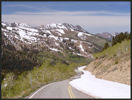
From West. The approach is described
in a downward direction. The entire route from the
top is paved and makes a great out and back road
ride. On June/4 the conditions at the top were
such that an almost through going "bikepath" had
melted out on the side of the road. The high
Wasatch Peaks on this side of the pass make for
cooler and more scenic conditions. A few
switchbacks descend steeply to Big Cottonwood
Canyon, leading to the Brighton ski area. From
there the long descent between alpine peaks is
just the right steepness to let the bike roll on
its own. An almost level stretch follows. Then the
road enters a spectacular canyon with vertical
cliff faces, the kind of difficult topography that
is rarely traversed by a paved road in North
America. At the end of the canyon Wasatch
Boulervard (Ut210) is a convenient way to contour
the benches north and towards Salt Lake City.
Other Approaches
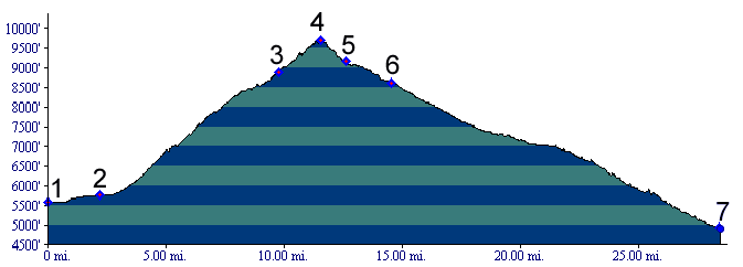
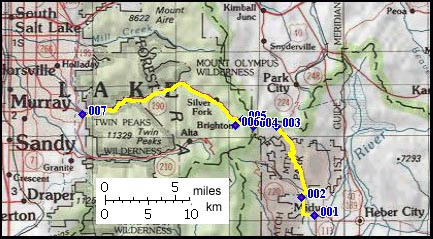
The entire road is already, on in the process of being - paved, to the junction with the Midway approach (June/07). This is a climb through ski condos with heavy delivery truck traffic, even when there is no snow. Where the condo city thins out, the construction to extend it up to the ridge line begins. Delivery trucks seem to be replaced by construction vehicles with tires topping out above a bicycle with rider on it. In my case a water truck was ready to wet down whatever dirt road there was left. When I finally believed I had reached the top of Park City, I passed under a bridge, that looked like the former little dirt road was about to be replaced by a six lane tollway over the bridge. "Skirunover" said the construction worker knowingly. Soon you'll be able to ski over the Guardsman Pass road like a 747 rolling over a beltway of a large city. However, the end of construction is in sight, since the top of the ridge is nearby - unless of course they construct a higher mountain. The spiritual high point of this climb was a chat with a construction worker about all this craziness, while waiting for construction traffic to clear. This is one dirt road that could use a dedicated bike path more than most city centers. The profile of this approach is included in the Wasatch Crest Trail summit(u) page. Tours Dayrides. (unpaved+paved): A loopride beginning in Midway, leading over Guardsman Pass to Holladay City in the Salt Lake Valley, then returning over Parley's Summit measured 82 miles with 7740 feet of climbing in 7:1 hours, using a Cateye A100 cycle computer. (m3:6.6.4) (single track+unpaved+paved): A loop
ride from Silver Crossing ( junction Ut248 - US40
) to Park City, up to Guardsman Pass, over the Wasatch Crest
Trail summit(u) down Mill Creek Canyon,
returning via I80 and Parley's summit
measured 64 miles with apr. 6400ft of climbing in
7:1 hours, using a VDO MC1.0 cycle computer
(m3:7.6.11). Guardsman Pass is a topological
shoulder on this route.
|
 Approaches
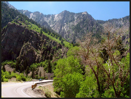
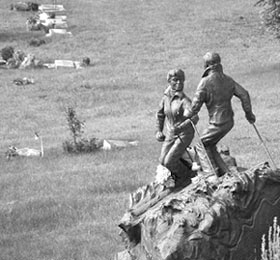 From Park
City. The picture of the grave marker illustrates
the economic and sentimental importance of skiing
to Park City. A bike ride to Guardsman Pass
illustrates the point further. I saw the marker
while looking for the way. The basic idea is to
head for main street, then a roudabout, 1 block on
the left ( you can only enter downtown from the
downvalley direction ). From there Marcek Ave.
begins to climb steeply.
From Park
City. The picture of the grave marker illustrates
the economic and sentimental importance of skiing
to Park City. A bike ride to Guardsman Pass
illustrates the point further. I saw the marker
while looking for the way. The basic idea is to
head for main street, then a roudabout, 1 block on
the left ( you can only enter downtown from the
downvalley direction ). From there Marcek Ave.
begins to climb steeply.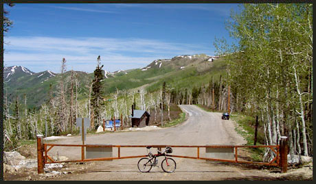
|
|
advertisement |
|
|
advertisement |