| |
| |
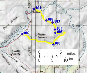
Kokopelli Trail m88
s(u)
 The Kokopelli Trail is 142 miles of canyons,
mountains and dessert bluffs between Loma,
Colorado and Moab, Utah. The Utah section of the
trail lends itself readily to being divided into
four major summits, all of which can be cycled as
day loops along with some additional roads. The
summit at mileage point 88 ( referencing the
Cobmoba brochure on the trail, third revision
1996, not corresponding to the mileage points in
the profile below ) is the easternmost summit that
explores the deep red cliffs and mesas that
surround the La Sal Mountains like a network of
natural moats. When the Colorado Plateau canyon
maze is yet further disturbed by the exposed mass
of magma of the La Sal Mountains, nature comes up
with a topography so amazing, confusing and
varied, that personally I never minded one bit
that I walked a significant portion of this rough
section of the trail. In order to take all the
pictures I wanted, I would have had to stop
anyway.
The Kokopelli Trail is 142 miles of canyons,
mountains and dessert bluffs between Loma,
Colorado and Moab, Utah. The Utah section of the
trail lends itself readily to being divided into
four major summits, all of which can be cycled as
day loops along with some additional roads. The
summit at mileage point 88 ( referencing the
Cobmoba brochure on the trail, third revision
1996, not corresponding to the mileage points in
the profile below ) is the easternmost summit that
explores the deep red cliffs and mesas that
surround the La Sal Mountains like a network of
natural moats. When the Colorado Plateau canyon
maze is yet further disturbed by the exposed mass
of magma of the La Sal Mountains, nature comes up
with a topography so amazing, confusing and
varied, that personally I never minded one bit
that I walked a significant portion of this rough
section of the trail. In order to take all the
pictures I wanted, I would have had to stop
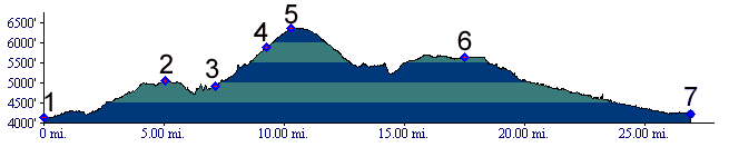
anyway.Elevations in the profile are slightly different than the ones shown in the official Cobmoba brochure. However this is what I come up with when I trace the trail on a map. Due to the trail conditions traversal of this route takes longer than the profile below would lead you to suspect, when compared to similar profiles in these pages.
Approaches From North. Dewey Bridge marks the magical
spot where Ut128 coming from Frisco finally
crosses onto the south side of the Colorado River
and thus grants access to a large area of Dolores
Canyons stretching to the Unaweep Divide. The
profile begins here. A gravel road with moderately
large rocks climbs steeply between sandstone
bluffs on a dip slope. The trail diverts from the
road at the "Top of the World Trail" ( or road )
on the right, only to depart from it immediately
afterwards to the left onto a single track wide
enough to be a double track. The wide single track section through a small,
narrow canyon is described as technical. I'm not
sure how technically competent my walking was -
but not very. After that little diversion the
trail rejoins the gravel to climb to the summit.
The summit is located on a shallow dip slope
traverse in open juniper forest. Here the field of
view widens to a full 180 degrees and for
the first time includes the Dolores Canyons to the
south.. A spot next to the trail shows that it has
been used as picnic spot.
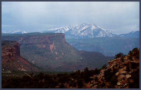
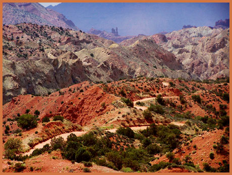
From South. The route is described in a
downward direction. The trail quickly becomes a
rough off road trail and the La Sal Mountains
enter the field of view for the first time, a
white crown on a set of red cliffs. Keeping with
the prevalent jargon used to describe the trail,
it can be called technical - rocky as hell would
also work. After a descent switching direction
back in a northerly direction, it suddenly becomes
apparent that a sheer canyon separates the trail
from mesas further west - right when the the trail
arrives at its rim. What follows is a series of
rough, rocky ascents and descents with vertical
cliffs not far from both sides. Included in this
is one descent covering several hundred feet, that
seems like somebody went out his way to gather all
the rocks in the area and place them on this
slope. This stretch, showing up in the profile
just before mile 15, is definitely 100 percent
impossible to ride, uh, I mean technical. And what
a beautiful walk it was. Dark clouds enveloped the
snow on the La Sals with a translucent curtain of
light. The cliffs above seemed like bloody teeth
and green cottonwoods sought shelter in rocky
depths. But back to the biking. Unexpectedly the trail
suddenly takes on a hard smooth surface as it
approaches Fisher Valley, which surprisingly is at
the same high altitude. At this point the route
description deviates from the Kokopelli Trail
itself, and continues down Onion Creek Road in
Fisher Valley, in order to facilitate the dayride
suggestion below. Now on a good dirt road, the
cyclist gets to "spend" at least some of the
uphill, he has worked for so hard. And this
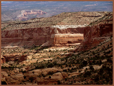
stretch too has its scenic wonders. Fisher Valley has the appearance of a large shoe
box. But something seems unusual about it from
this vantage point. The shoebox seems to terminate
in mid space. The reason soon becomes apparent.
The floor gives way to a contorted canyon with
spires of every imaginable shape and size (3rd
picture). Now all that remains are approximately
17 crossings of Onion Creek, before the rider is
delivered back to Ut128 in Professor Valley.
Sidetrip. The steep out and
back climb on End of the World road leads to an
amazing vantage point above the Fisher towers and
opposite the La Sal mountains. Climbing up the dip
slope, there is no hint of what is ahead until you
arrive at the rim. It almost seems a shame to
spoil the surprise by mentioning it here, or
putting up a sign at the junction.
Dayride. A loop ride on the two approaches
described above, connecting back to the starting
point along paved Ut128 measured 38 miles with
4890ft of climbing in 5.3 hours (m3:06.05.22).
|
|
|
advertisement |
|
|
advertisement |