| |
| |
North Creek Pass
(aka Abajo Loop Road Summit)
In a similar manner that
international tourists, standing at Grand Overlook
in Canyonlands National Park, observe that the
Abajo Mountains are lower than the La Sal
Mountains, early Spanish explorers did too. But
naming them the "low mountains" (abajo means low)
may not exactly have hit the nail on the head. It
is true that Abajo Peak (11360ft) is close to
1500ft lower than Mount Peale (12721ft) in the La
Sals. But then - the Spaniards couldn't know that
the yet to be built Abajo Loop Road would someday
reach almost two thousand feet above the La Sal
Loop Road (8320ft).
Admittedly this comparison is
really between apples and oranges, since the La
Sal Loop Road is paved (at least by Utah
standards) and the Abajo Loop Road is clearly not.
But even comparing the Abaho Loop road with the
highest good dirt road in the La Sals - this would
be Geyser Pass at 10540ft - North Creek Pass still
is 800ft higher.
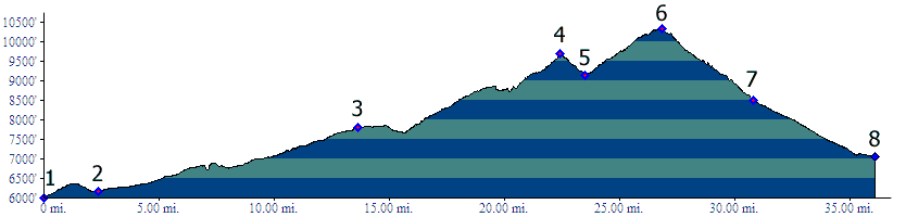
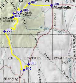
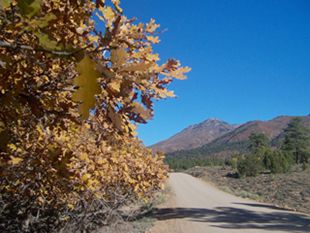
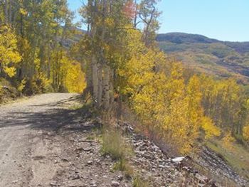
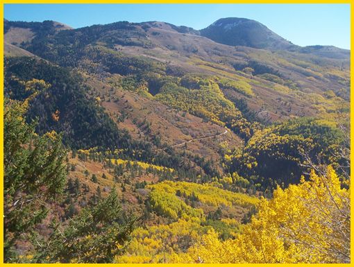
From South. In order to illustrate a loop ride, I chose a point on US191 north of Blanding, where it crosses the Recapture Reservoir. US191 south of Blanding actually starts from a lower elevation. To start the ride you have to get onto Blue Mountain Road in some manner. This is long long ridge that gradually creeps up a scenic shoulder of Mount Linnaeus, the lower western peak, of the two dominant Abajo Peaks. Pavement ends where the road crosses into the Manti La Sal National Forest. As the road contours around to the east, and dips through drainages, there are good framed views of Mount Linnaeus and its stratified rocks. Crossing Jackson Ridge to the east of this peak, gives all appearances of being the major pass crossing of the day. This lower crossing at point 4 above also has the best views and most of the picture below are taken near that area.. Signs inform that Blanding is 22miles away, while Monticello is only 14 miles distant. Furthermore there is a Skyline Trailhead (a very popular name in Utah) 1.5 miles to the west. However the highest point of the ride on North
Creek Pass is still ahead, and the next 14 miles
ahead to Monticello will probably take longer than
the 22miles back to Blanding, especially if snow
on the road makes travel difficult. If there are
any snowy patches at all in the shade on the short
descent to the low point between the two summits,
there will be much more snow to come. As you start
to gain altitude again, this time between Twin
Peaks and Horsehead Peak, you can see the size of
the climb ahead by looking at the apparently
straight diagonal that cuts across Horsehead Peak.
The path between Twin Peaks and Horseheah Peak is
a named pass too. The trailhead sign is clearly
labeled and calls it Spring Creek Pass. It is
closed to bicycles from Oct11 to May15. Chances
are there is snow on it during that time anyway.
This second climb seems to have much less fall
color than the intial climb to Jackson Ridge. The
view from the top is limited to Jackson Ridge.
From North. (described downwards) If
there is a patch of ice on top, it is a sign of
things to come. The road for a large part stays in
the forest on the bottom of the west facing slope,
that gets noticeably much colder air. Snow melt
takes much longer, and the snow free east facing
slope is tantalizingly close in the sunshine, just
out of the shade so it seems. Under these
conditions, hitting pavement may seem like hitting
gold. When this happens, downtown Monticello and
its dining and shopping attractions (pizza, Subway
sandwiches or a prepackaged morsel from the Blue
Mountain foodstore) are only 4 miles away, and
they are straight as an arrow and all downhill,
with great distant views of the western most
lonesome cones of the San Juan Mountains in
Colorado. Dayride. PARTIALLY PAVED / UNPAVED North Creek Pass , US191 Monticello - Blanding
s(u) : Blue Mountain Road > North Creek
Pass > Monticello > US191 Monticello -
Blanding s(u) > Recapture Reservoir > Pinyon
Ridge Road > Blue Mountain Road > back to
starting point: 56.4miles with 5970ft of climbing
in 5:31hours (VDO MC1.0 m3:11.10.16) |
 Approaches
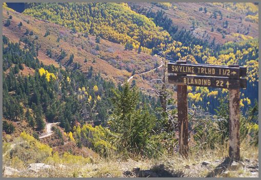
|
|
advertisement |
|
|
advertisement |