| |
| |
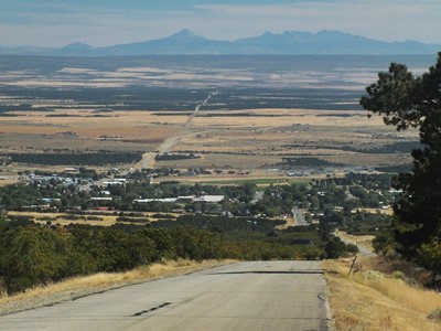
North Creek Rd / Hart's
Draw Rd s(u)
From looking on maps, it is not
obvious that this is actually a completely paved
loop. But maybe I shouldn't make conclusions about
other people, based on me looking at my maps.
After all - my maps are not from this year, and
other peoples' looks at maps may be more
perceptive. In any case, there is virtually no
traffic (maybe because other people like me don't
know it is paved all the way through ?), fantastic
views, immaculate extremely wide pavement, and a
great climbing workout - except for the part of
the profile on Ut191. North Creek Road by itself
is definitely the road of choice to enter the
Needles district of Canyonlands National Park.
This is great, and so there is nearly no traffic
on this wide, scenic, gently climbing highway.
With each wide meander up to Shay Mountain, the
far vistas on the buttes, lining Colorado
tributaries and also the La Sal Mountains
increases. Before the road enters the forest, a last
viewpoint with parking lot invites for one of the
last vista. A strategically placed nice bench
invites for a rest. It is inscribed "Obesity
Disaster Bench". I doubt that the bench came
that way, even though the inscription looks fairly
professional and not at all like graffiti. In any
case, there are countless countries with hundred
times as many scenically placed benches and none
of them seem to have obesity problem as severe as
in the US. If anything, I would speculate that
benches encourage to appreciate and explore the
surroundings. If you do it without motorized
support it has the opposite effect, than the
inscription wants to make you believe. But my favorite view of the La Sal Mountains
actually comes a little later, exactly before the
road enters an open forest and then reaches the
summit.
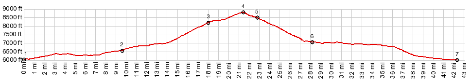
Ride with this point as highest summit: COMPLETELY PAVED: ( < CRK8 Dolores Rim(sh) | Ut261 via Snow Flats Rd(sh) > ) North Creek Rd / Hart's Draw Rd s(u) , additional out and back : short distance up Hart's Draw Rd > up Hart's Draw Rd <> out and back to end of pavement west on North Creek Rd direction Shay Mtn >> North Creek Rd / Harts Draw Rd s(u) > Monticello with detour of several loops around town > US191 north > Co211 west > backup Hart's Draw Rd back to starting point with additional out and back : 56.4miles with 4410ft of climbing in 5:13hrs (garmin etrex30 r4:19.10.1) |
 From East-2. (described
downwards). The area in the trees up here is a
regular trailer camping city. After the dirt road
from
From East-2. (described
downwards). The area in the trees up here is a
regular trailer camping city. After the dirt road
from |
|
advertisement |
|
|
advertisement |