| |
| |
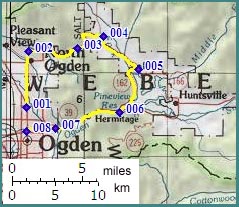
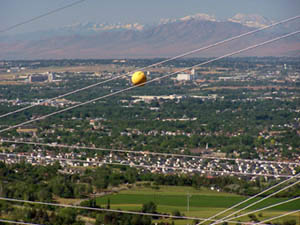
North Ogden Pass
 Spectacular alpine scenes, that
are set in an urban environment, just aren't
tourist attractions. People there just go about
their business as usual. There are no tourist
traps, that families flock to in their SUVs ( or
formerly station wagons with a picture of wood on
the side ). You don't find go-cart races,
amusement parks or T shirt vendors, pony rides or
ATV rentals. Instead people push their shopping
carts across mile long parking lots into
Wal-Marts, fill up their cars or look for
missionary suit sales ( second picture ) without
ever taking notice of the 5000ft wall of
mountains, that blind the eyes upon exiting
Wal-Mart. This gives the area an attractive
realness that cannot be achieved by a tourist
resort. North Ogden Pass leads out of this
suburban area over a steep crest in the Wasatch
Range. Considering its urban character, traffic
conditions are pretty good. Spectacular alpine scenes, that
are set in an urban environment, just aren't
tourist attractions. People there just go about
their business as usual. There are no tourist
traps, that families flock to in their SUVs ( or
formerly station wagons with a picture of wood on
the side ). You don't find go-cart races,
amusement parks or T shirt vendors, pony rides or
ATV rentals. Instead people push their shopping
carts across mile long parking lots into
Wal-Marts, fill up their cars or look for
missionary suit sales ( second picture ) without
ever taking notice of the 5000ft wall of
mountains, that blind the eyes upon exiting
Wal-Mart. This gives the area an attractive
realness that cannot be achieved by a tourist
resort. North Ogden Pass leads out of this
suburban area over a steep crest in the Wasatch
Range. Considering its urban character, traffic
conditions are pretty good.
Approaches
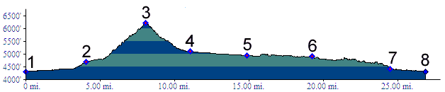
Down South. (described downward) The valley fault block on the eastern side sits much higher, and so the descent goes even faster. The shoulder disappears and yacht-pulling traffic around Pineview Reservoir picks up. Funny how these things always happen together. There are two ways to get around the lake. The profile follows the shorter route to the west of the reservoir.
The bottom most section is a special treat, if
you feel about bike paths the same way as I do.
What looks like a turnoff to a business ( a
restaurant called Rainbow Garage or something
weird like that ) at the exit of the canyon, is
really the beginning of the Ogden City River
Parkway trail. It winds through parks, Cottonwood
groves, around tree trunks and over bridges to
connect with the Centennial Trail system. Two
photos are included in the picture page. Tours Dayrides. A loop ride starting in North
Ogden, over this pass, through Eden, and Ogden
Canyon back to the starting point measured 58
miles with 2600ft of climbing in 4:4 hours. This
also includes many extra miles on the Ogden River
Parkway trail system and an out and back run to
Huntsville (m3:7.06.09). History The Fur Trapper Period: An Indian trail crossed North Ogden Pass, and another one ascended Ogden Canyon since before it was popular to keep track of these things. North Ogden Pass was first discovered by an Anglo American from the east side. Cache Valley had been a favorite hunting ground of early trappers. In 1825 Peter Skene Ogden led a party out of Cache Valley over the unnamed divide south of Paradise, and then crossed this pass into what is now North Ogden. The Overland Trail: ( | Parley's Canyon s(u)
> ) By 1849 exploration of the west had
become official business. New Mexico was now US
territory, placer gold was discovered in
California, and mormon development of Utah went
full speed ahead. Howard Stansbury, of the US Army Corps of
Topographical Engineers, was put in charge of
mapping a supply route between South Pass and the
Oregon Trail to Salt Lake City. His expedition was
guided by Jim Bridger and included 18 other men, 5
wagons and 46 mules and horses. In August 1849 Stansbury left Fort Bridger,
traveled through today's Evanston area, and then
crossed into the Salt Lake Valley over North Ogden
Pass, using one of the Indian trails. He was the
first to officialy notice the terrace formations
that had to be left by a large ancient sea, which
we now call Lake Bonneville. But the route, which
he eventually recommended as a supply route for
Salt Lake, took quite a different path. back to cycling Utah's summits and passes |
 From
North. There are many ways to ride up onto
the suburban benches. Taking the main street, here
called Washington Street, heads straight for
Willard Peak. When it gets to the terraces
deposited by the ancestral Lake Bonneville, the
route makes a 90 degree turn to the right.
Suburbia ends abruptly and Willard Peak already
seems to have shrunk from this perspective.
Traffic is generally much less than the population
density would lead to suspect and there is a good
shoulder on the steeply climbing road. The road
does not switch back but seems to converge with
power lines over the pass. When they seem to do it
a second time, it actually happens. Meanwhile the
ocean of houses in front of the inland salty sea
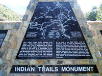
has disappeared behind trees. At the top the
Skyline Trail crosses the road and an Indian
Trails Monument illustrates five Indian trails in
the area, one of them leading over this pass.
From
North. There are many ways to ride up onto
the suburban benches. Taking the main street, here
called Washington Street, heads straight for
Willard Peak. When it gets to the terraces
deposited by the ancestral Lake Bonneville, the
route makes a 90 degree turn to the right.
Suburbia ends abruptly and Willard Peak already
seems to have shrunk from this perspective.
Traffic is generally much less than the population
density would lead to suspect and there is a good
shoulder on the steeply climbing road. The road
does not switch back but seems to converge with
power lines over the pass. When they seem to do it
a second time, it actually happens. Meanwhile the
ocean of houses in front of the inland salty sea
has disappeared behind trees. At the top the
Skyline Trail crosses the road and an Indian
Trails Monument illustrates five Indian trails in
the area, one of them leading over this pass.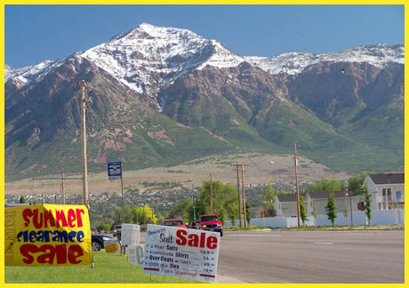
 The best way to continue from here
on a bicycle would be to take the paved road to
Mountain Green and Weber Canyon. But instead the
profile seeks the shortest way back down and that
is Ogden Canyon. Signs discourage cycling and
walking in Ogden Canyon because of a narrow
shoulder, but they do not prohibit it. The
shoulder is variable from small to nonexistent and
limited on the right by a construction barricade
that is supposed to make falling off the
embankment into the river less likely. I rode the
route during a Sunday mid afternoon when all the
boaters were still boating or pulling their boats
around the reservoir and had no problems. But I
can easily imagine more difficult traffic
conditions.
The best way to continue from here
on a bicycle would be to take the paved road to
Mountain Green and Weber Canyon. But instead the
profile seeks the shortest way back down and that
is Ogden Canyon. Signs discourage cycling and
walking in Ogden Canyon because of a narrow
shoulder, but they do not prohibit it. The
shoulder is variable from small to nonexistent and
limited on the right by a construction barricade
that is supposed to make falling off the
embankment into the river less likely. I rode the
route during a Sunday mid afternoon when all the
boaters were still boating or pulling their boats
around the reservoir and had no problems. But I
can easily imagine more difficult traffic
conditions.|
|
advertisement |
|
|
advertisement |