| |
| |
Promontory Summit(sh)
Promontory Summit is where the 1869
transcontinental railroad crossed the Promontory
Range. Here - finally the "Golden Spike" was
driven into the ground, to unite the railroad
building efforts from the east and the west coast.
Much of the old railbed is mountain bikable. Actually there are two parallel
railbeds, which to me is the most fascinating part
of the whole story. Both railroads received plenty
of incentives from the US government in the form
of landgrants, to keep on building. The two
railroads kept right on laying tracks past each
other for 250miles in the hope of obtaining more
landgrants. It is amazing to see how close the two
tracks are. Workers from the two competing
railroads could have carried on a conversation
while laying track past each other in opposite
directions. Only one of these former parallel
railbeds is bikeable, a large portions is also
open to cars. But I never saw any cars, bikers or
hikers for that matter. The highest point on this
route happens to be on a partially paved road,
that has to be used to detour a closed part of the
railbed on top. It is not actually the same point
as the old Promontory Divide, and that is the
reason why I put an (sh) behind it.
 Approaches A few signs point out sites, such as the siding
Rozel, named after the nearby mountains, where
helper engines were once added for the short climb
over the divide. After several miles of this, the railbed turns
eastwards, heading for an ever so shallow saddle,
really almost a plain in the Promontory Range. A
sign touts the severe grades and the severe
railroad building efforts, but the elevation gain
is hardly more than 500ft, and it barely looks
like a hill.
Continuing up the gentle grade, we pass a sign
celebrating abusive labor practices, such as the
fact that Chinese laborers were forced to lay a
record 10 miles of track in a day, while being
prohibited to take a break for lunch. The railbed continues parallel to a dirt road
till shortly to Promontory Summit (without the
(sh) ). Shortly before getting there, the road
following the rail bed terminates on the nearby
road, and old rails have been laid down on the
railbed to make it look more authentic on the
summit. The summit has been portrayed in countless
photographs. In these photographs replicas ( or on
1869 photographs - the real thing ) of the two
elaborately decorated steam engines meet one
another, one Central Pacific locomotive from
California, and one Union Pacific engine arriving
from the east. But actually, during my last visit there were no
engines there, and without them, this modern
visitor center, looking identical to a Mormon
church building or a business bungalow seems a bit
overbuilt. To gain admission the charge is 7
dollars a vehicle, loco or no loco. Upon pointing
out that my vehicle was a bicycle the price was
lowered to 4 dollars. It seems they don't see many
bicycles here, in spite of the fact that this
seems like a major cycling attraction. The visitor center is the highest point on the
railline. But travel is now restricted to the
road, and that reaches a high point at the
junction with the unpaved and unsigned Salt Wells Rd.
From East. (described
downwards). After a short distance a dirt road and
then the signed East Grade Autotour follows part
of the railroad grade again. - Nice views of the
valley and Wasatch Range, framed by deep cuts and
not a single tunnel, but a small natural arch next
to the railbed. The short detour soon ends on the
road again. But with a bicycle it is possible to follow the
railbed further on the Big Fill Trail. The main
attraction here are the site of a rickety old
trestle bridge parallel to "big fill" dirt
embankment, put up by the competition. The trestle
was soon abandoned, and no sign of the bridge
remains. The grade detours far to the north of the
road, finally passes a ranch and comes out on Ut83
at the rocket company plant.
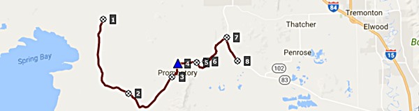
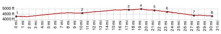
A Dayride with this point as highest summit: PARTIALLY PAVED / UNPAVED ( < Salt Wells Rd( s(u) |) Promontory Summit(sh) x2 : near trailhead to BLM railgrade Rd <> West Grade Auto Tour route east <> Golden Spike Dr east > Promontory Summit(sh) x2 <> unmarked dirt road shortcut to East Promontory rd <> Promontory Rd south to turnaround point several miles past change from pavement to hard medalled: 72.5miles with 2800ft of climbing in 6:04hrs (garmin etrex30 m5:17.9.28). A Dayride with this point as intermediate point is on page: Salt Wells Rd s(u) 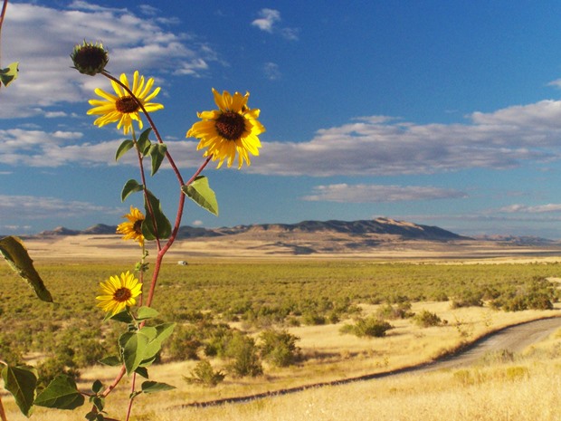 |
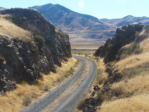 Still - the deep cuts
let you know you are on a railbed and the distant
mountains give this 90 degree left turn a special
appearance.
Still - the deep cuts
let you know you are on a railbed and the distant
mountains give this 90 degree left turn a special
appearance.|
|
advertisement |
|
|
advertisement |