| |
| |
Skull Rock Pass
I've been exploring parts of Utah
for many years, and it still took me decades to
first discover the incredible nature and beauty of
this area called the Western Dessert (west as far
as Utah is concerned). My first hint was a Flickr
Group dedicated to Utah's Western Dessert photos.
There are no National Parks here or National
Monuments, and I think it's good this way, just
lots of BLM land with plenty of hard surfaced
gravel roads, and at least one dry lake bed, that
are a thrill to run along on a bicycle. US6 over Skull Rock Pass is one of
the few paved roads that goes through this area.
Skull Rock Pass is one of two paved summits
between Lake Sevier and the Nevada border. It
makes an excellent starting point to discover
other unpaved roads in the Western Dessert, and a
great ride on its own. It's not always just the
size that makes a mountain pass interesting. This
one is small and gentle by any standard, and an
unusual, austere, spectacular scenic marvel all
the same (but only if you are into desserts in a
deep way).
From West. (also
desribed upwards) At the low point between this
summit and the next unnamed summit to the west on
US6 (which is actually quite a bit higher) the
road transitions from following a twisting canyon
to something drawn with a ruler, as if trying to
resemble the mountains around this valley. The
road is going to go over a low flank of the House
Range. The highest peak of this range forms a
sheer wall, called Sawtooth Mountain, and it's
hard to take your eyes off it, especially in late
evening light. For a closer look the unpaved Thule
Valey road runs along to the north. Riding that,
you also discover that this is a wilderness study
area, which would make me happier if they wouldn't
keep bicycles out and horses in.
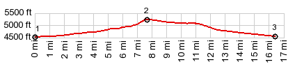
Dayride with this point as highest summit: PARTIALLY PAVED / UNPAVED ( < Wheeler Peak Scenic Dr(ow) | Thompson Pass > ) Skull Rock Pass x2 , additional out and back: unlabeled road, short distance north of US6, east of House Range > down this road > US6 west > Skull Rock Pass > Thule Valley Rd north > unlabeled road south back to US6 > US6 east > out and back on Tule Valey Rd south or parallel on dried lake bed > US6 east > Skull Rock Pass <> short out and back on 3c Rd south > back ot starting point:59.0miles with 1840ft of climbing in 5:05hrs (garmin etrex30 m3:19.11.12) Notes: first exploratory ride in Utah Western Dessert - definitely a place to come back to in the future. On Thule Valley Rd south I met Trey A., the only other person on this dessert road today. He was here practicing his solo climbing skills on boulders in a renowned climbing area along South Thule Valley Rd. He also had a fat tire bike along on the roof. And so we rode north on the Thule Valley Hardpan, a dried lakebed - easily the most enjoyable part of the day. Lots of talk about his past ride from Oklahoma to Columbia, among countless other topics. He is on his way to winter in a climbing area in California. 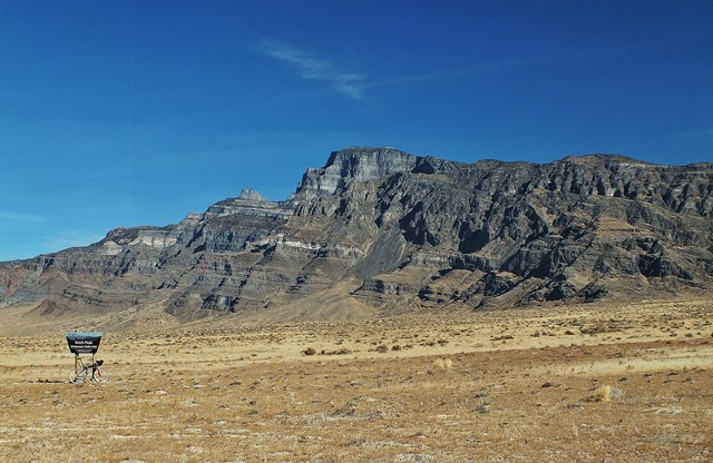 |
|
|
advertisement |
|
|
advertisement |