| |
| |
Smithsonian Butte Rd -
Gooseberry Mesa Rd(sh)
This is a dirt road loop in some
spectacular Zion adjacent scenery. Unfortunately,
in order to make a loop, you have to ride on an
unpleasant and dangerous paved road. If there is a
way to skip this and use a trail instead, please
let me know.
From South. (described
downwards) An extreme washboard surface road,
heads straight as an arrow towards Ut59. This is
another paved highway, where the Utah Department
of Transportation has spared no expense to make
cycling on it as life threatening as possible.
Rumble strips completely destroy the very narrow
shoulder for cycling, and bicycles have to ride in
a narrow lane of traffic with heavy traffic and
sleepy truck drivers. After several miles of this the profile goes
right onto unpaved Sheep Bridge Rd and looses more
elevation. Near this turnoff several popular
single track trails cross the road. It would be oh
so helpful if one of these trails would reach the
top of Gooseberry Mesa and the trailhead there.
Then you could do this loop without the dangerous
Utah paved roads, and without the majority of
washboard surface. But to the best of my knowledge
the trails leaving from here do not reach to the
top of the mesa
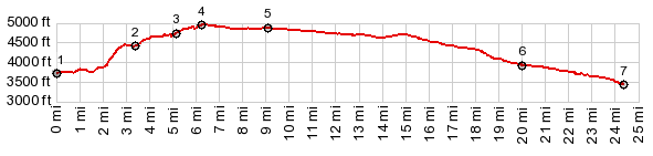
Dayride with this point as highest summit PARTIALLY PAVED / UNPAVED ( < Hurricane Mesa s(u) | Utah Hill Summit > ) Smthsonian Butte - Gooseberry Mesa Rd(sh) , additional out and back: apr 1 mile west of jct Mesa Rd - Ut9 > Ut9 east > Rockville > Grafton Rd south > Gooserry Mesa Rd south <> out and back to end of Grafton Mesa Rd > Smithsonian Butte - Gooseberry Mesa Rd(sh) <> out and back to Gooseberry Trailhead > Main St south > Ut59 west > Sheep Bridge Rd south > Ut9 west back to starting point: 49.3miles with 3580ft of climbing in 4:45hrs (garmin etrex30 m3:19.10.18). Notes: I have never been passed by so many hundreds of mountain bikes fastened to roof racks on cars as in the Goosberry Mesa area, without a single one of those bikes being ridden on the road. This is a popular single track area. They say, americans need cars for everything. That is especially true for mountain biking in this area. But with paved roads obliterated by rumble strips, there is really no alternative. Otherwise .... the scenery is fantastic. |
|
|
advertisement |
|
|
advertisement |