| |
| |
FR249 summit(u): Star Point
The eastern escarpment of the Wasatch Plateau behind Ut10, between Huntington and Price appears like a series of steps receding into the horizon. The clear dessert air and distance of the plateau make comprehension of its size difficult. A ride to Star Point summit(u) corrects this situation. While many plateau climbs ascend canyons in order to emerge on a high, forested plain, keeping views well hidden, the northern approach to this summit is filled with switchbacks, exposed rock ledges and far views.
From South. Mohrland Canyon is one way to approach the point from the backside. Mohrland Canyon Road leaves Ut10, 2 miles north of Huntington at Huntington Lake State Park. The paved road runs up an alluvial fan to the plateau. At the entrance to the canyon it services a small coal seem, a railhead and an oil well. Steeply climbing FR101 leads past old mining structures of the Mohrland mine to a heavily forested plateau top. A few views are obtainable between the trees. Once on the plateau, the road continues climbing ever so gently, cresting over a few open spots that allow orientation with respect to Huntington Canyon and the Bookcliffs. The turnoff to Star Point from FR101 is signed. The point of highest altitude is reached just after this turrnoff, in between grazing cows that manage to keep a few spots in perpetually evil smelling mud, so that the bike is better carried around them.. From North. The approach is first
described in a downward direction. Star Point is
about 200 feet lower than the highest point
traversed on the route. A smooth roller coaster
road heads from the highest point to a series of
communication towers ahead. This is Star Point. A
series of vistas begins 1/4 mile before reaching
the point. The first view is west and north to
where the purple Bookcliffs terminate into the
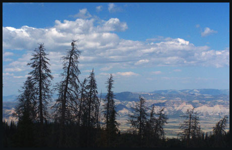
Wasatch Plateau. From the point the dessert
landscape in Castle Valley appears like a table
cloth that is being pulled upwards by series of
fishing hooks. A steep, somewhat rocky, but
perfectly ridable descend leads around a ridge in
the plateau to open the view on the last part of
the descend, a series of traverses that lead to
paved switchbacks on the opposite face. The
pavement is in a state of creeps and cracks and
bulging deformations. But it does speed up the
descend and soon the cyclist is rolling down a
smooth, long, straightaway over uniform grade
alluvial fan surfaces, dissected by curtain like
ravines back towards Ut10. Climbing up the same approach, one has a lot more
time to look at the pattern of ramps and fills,
created by mining reclamation, just at the point
where the road enters the plateau. At this point
the road also picks up grade dramatically. The
abandoned-like nature of the road, sage spilling
over guard rails and large plants making
themselves at home in the cracks, give the visitor
a "last cyclist on earth" type of feeling. In
spite of all this solitude, pavement reaches one
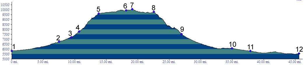
of the highest spots in the Price area ( if not
the highest ), located between points 8 and 9 on
the profile. It also makes a great out and back
road cycling workout, if you don't mind a few
cracks in the pavement.
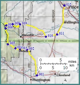
Dayride A loop ride from Huntington up Mohrland Canyon,
with an additional out and back leg to the bitter
end of FR101, then continuing over the FR249
summit(u): Star Point down to Ut122 and Ut10 back
to Huntington measured 61 miles with 5800ft of
climbing in 6.2 hours (m3:06.09.10). back to cycling Utah's summits and passes |
 Approaches
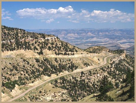
|
|
advertisement |
|
|
advertisement |