| |
| |
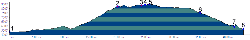
Uinta Summit
The crest of the only major
mountain range in the US extending in an east west
direction, the Uintas, is not crossed by a paved
road. Instead the summit carrying its name crosses
the eastern fringe of the range. Despite a long
steep climb on the south side, a significant
fraction of the total climbing exists of rolling
hills over the forested top. These smaller ups and
downs do not show up in the profile. There is a
summit sign without name. Curiously the point of
highest elevation is slightly north of this spot.
The road is also marked as a pass on old state
maps, and Touraide maps. But those maps don't
apply this name. Marshall Spraque, in his book
"the Great Gates, the story of the Rocky Mountain
Passes" calls the pass Uinta Summit. The name is
not commonly used today.
Approaches
From North. There are two paved northern
approaches which join at about the midpoint. The
ascent from Dutch John (Wyo), shown in the third
picture, leads up from the Flaming Gorge Reservoir
Dam. This is also the approach shown in the
profile. It is a little steeper and has less
traffic, not that traffic is a problem on the
other approach. On a dayride over the pass to
Flaming Gorge the point below the dam is an
interesting turn around point. The access road is
paved all the way and it's the lowest point
reachable by bicycle for quite a distance, since
the up canyon area is flooded. The other ascent (not shown) starts from Manilla
(Wyo) (6236ft). The most interesting sidetrip is
through Sheep Creek Canyon, a side canyon of
Flaming Gorge that is not flooded, located at the
bottom of this approach.
Dayride. A dayride starting at a campsite a few miles north of Vernal to Dutch John and back measured 77 miles and 7308ft of total climbing, using a Vetta100A cycle computer. 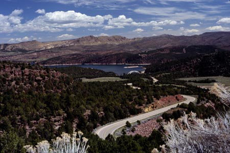
|
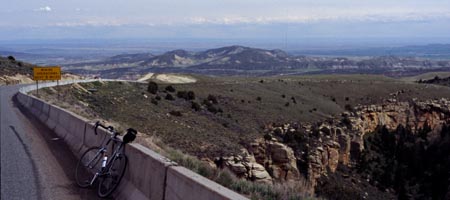
 From South. Ut44 leaves
Vernal in a mathematically orderly fashion by
making a 90 degree turn north from Main Street.
The next turn encountered is forced by crossing a
hogback ridge. Steinaker Reservoir waits on the
other side. The first low summit is encountered in
this complex of arid foothill hogbacks, cresting
at about 6000 feet and descending back to 5650
feet. Here the climb into the Uintas starts in
earnest. Loosely flung switchbacks wind up a
slanted plateau, dissected by small canyons. Miles
before approaching the summit the road enters a
forest and seemingly rolls along forever through a
high plateau that has a much lusher appearance
than the valley. Without a profile it is hard to
determine exactly where the summit is. Even the
highway department seems to have missed the spot
by half a mile when placing the summit sign.
From South. Ut44 leaves
Vernal in a mathematically orderly fashion by
making a 90 degree turn north from Main Street.
The next turn encountered is forced by crossing a
hogback ridge. Steinaker Reservoir waits on the
other side. The first low summit is encountered in
this complex of arid foothill hogbacks, cresting
at about 6000 feet and descending back to 5650
feet. Here the climb into the Uintas starts in
earnest. Loosely flung switchbacks wind up a
slanted plateau, dissected by small canyons. Miles
before approaching the summit the road enters a
forest and seemingly rolls along forever through a
high plateau that has a much lusher appearance
than the valley. Without a profile it is hard to
determine exactly where the summit is. Even the
highway department seems to have missed the spot
by half a mile when placing the summit sign.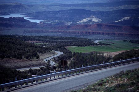
|
|
advertisement |
|
|
advertisement |