| |
| |
Ut 313: Island in the sky
s(u)
The title of this page is sort of
misleading. But I am going to stick with it. These
pages are organized by summit points. Most of the
time this makes much sence, since the highest
point is often a famous scenic pass. But it Utah,
where canyons are often even more wondrous places
than mountain ridges, this doesn't hold true. So,
maybe the the name of the page should be "the
Shafer Trail". But then it should also be Long
Canyon and "Island in the Sky road". The fact is,
that all these routes summit at the same point,
and that point is the turnoff to Deadhorse State
Park on Ut313.
1. Paved Approaches The first profile stays on pavement all the way. It is difficult to think of this road as a paved two way summit, ie. one with two separate approaches. But it just meets the cutoff criteria, that I have set for these pages, that is - the western approach is just a little higher than the minimum 500ft.
 Approaches: Approaches:From South (via Ut313). For me this
road has often been the last lazy downhill of
the day, where you just sort of bake in the
evening light, as much as the memories of
climbing up the Shafer Trail (or road). Time for
one last sweeping view across the rock fins to
the La Sal Mountains, wearing late light with
deep shadows for the occasion. But I'll try to
describe it in an upward direction. Leaving Moab, a meticulously paved bike path
follows Ut191 to the entrance of Arches National
Park. From here the bike path takes advantage of
the old Ut191 road bed. What used to be a funky
crumbling surface has been upgraded to something
suitable for even the most fickle, super skinny,
treadless tire, resembling an inner tube, but
possibly having none. (Oct 2011). The bike path
stays even in a different drainage than the
road, so that peace is complete. It crosses the
road at the Gemini Bridges trailhead and then
ends at the jct with Ut313. That's just as well as far as the profiled
route is concerned, because it continues up
Ut313. After extricating itself from Seven Mile
Canyon, in the shade of Merimac and Monitor
Buttes, the road runs along a very gentle ridge
line. During early light this gives occasion to
see if the Henry Mountains have snow already or
still snow on them, and during pretty much any
light condition you can tell the same thing
about the somwhat closer La Sal Mountains. The
following side road turnoffs are signed Mineral
Bottom Rd., Gemini Bridges Rd. If looking for
something else, bring maps with plenty of
detail. from West (via Ut313). (described downwards). An ever so gentle straight, rolling downhill from "The Knoll" leads to the entrance of Canyonlands National Park, and immediately afterwards to one of its most amazing stretches of road, named "the Neck". If this is the neck, then the island must be the head, and the Shafer Trail is a jugular descending on the east side to the Colorado River. When crossing the neck, heads turn east. The west side is often neglected. But Taylor Canyon on the west side would be a major attraction, if there wasn't anything super major on the other side. Shortly after this wake up call, the road continues across Grey's Pasture, as if it were crossing your average variety of verdant western plain, with mountains in the far distance. Two junctions on the left lead to Grand Viewpoint and Green River Viewpoint. In order to get to some kind of bottom on this side, and still staying on pavement, the profile goes to Upheaval Dome, where it reaches a low point just before reaching the picnic area at the end of the road. 2. via Shafer Trail The second profile combines the most remarkable of the approaches to this point, the Shafer Trail (which is a dirt road of sorts) on the north, with paved Ut313 on the south side. picture page of Shafer Trail Approach second picture page of Shafer Trail Approach
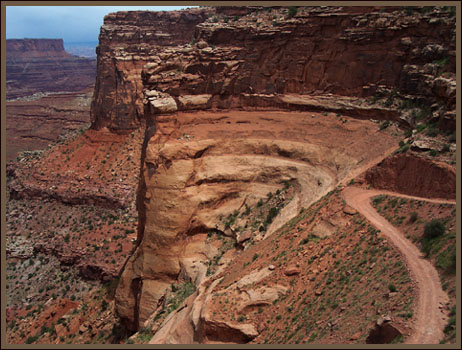
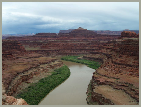
Approaches From North via Potash Road and Shafer Road: The ride from Moab to the starting point of the profile makes a great paved out and back ride in itself. It follows Ut279 on the north side of the Colorado River next to deep red vertical walls. But the road creeps along through fern greenery, a comforting contrast to red hard edges above. The road is just about as perfect as it can get in the peaceful river canyon cycling category. The paved road ends shortly past the Potash plant. Here the profile starts. The initial short climbs lead to an industrial
landscape of fenced evaporation ponds, resembling
Lake Powell without boats, which in essence is
also just a big evaporation pond. Here the water
is died blue to speed up the loss of water even
more in order to harvest a host of minerals. The
road contours to a vantage point above an
entrenched meander, deep red rock recesses
retreating in every conceivable direction, views
leading to spots that are visibly naked but appear
impossible to reach - in other words - the perfect
lunch spot. A short shelf road works itself away
from the Colorado, but appears stuck ona ledge on
the big staircase. But a crack opens up between
Grolsch beerbottle shaped rocks, and leads to the
natuional Park boundary and the junction with the
White Rim Trail. The final climb is now in full
view. The half dozen switchbacks really do not
cover a monstrous amount of altitude. But they
seem chizzled into the the rocky slope, situated
between sheer cliffs. With every switchback the
White Rim Trail becomes more and more threadlike.
A long traverse under the final lip of the rim
completes the dirt road section at the junction
with Ut313. Turning right, you exit the national
park immediately afterwards. A few rolling hills
lead a couple of hundred feet higher. The top is
located next to a nipples shaped mountain on the
plateau, which comes into view soon after turning
onto pavement. The high spot is also where the
turnoff to Dead Horse Point Road is.
3. via Long Canyon When Long Canyon is combined with a ride up Shafer Canyon, it is called the Jughandle Loop. This name may come handy when looking for the Long Canyon turnoff from Ut279. The sign says "Jughandle Loop Parking". Sometimes I think a dictionary of Moab area directional signs would be a welcome addition to the available guide literature. The profile below however - shows Long Canyon combined with the other possible approach for a loop ride. Again this is the paved southern approach to Ut313.
Eastern Approach: (described downwards)
Soon after turning off onto the road to Dead Horse
Point, a wide dirt road keeps aiming straight for
the rock fins above Moab and the La Sal Mountains,
while the Dead Horse Point road turns slightly to
the right. The wide dirt road descends, just
noticably, and climbs a minute amount to crest at
a point called Pucker Pass. Soon after that the
character of the road changes radically. The first
reason to slow down are the views over Long
Canyon. Then the road makes the break through one
of the cliff forming formations (not quite sure
which one) through sheer rock. Next comes a
strutural bridge or arch, that is neither a
geological bridge or arch. Maybe I should just
call it a hole, or better yet explain what
unlikely thing it really is. It's a giant boulder
leaning on a cliff, with enough space between them
to contain the road. Better to see for yourself. A
few more switchbacks under one of the largest
alcoves, in country that contains many very large
alcoves, and road "breaks" through a final wall of
rock, that looks rather like a set of curtains
that has opened just a bit for the final applause.
As already mentioned above, the Ut279 sign at the
turnoff reads "Jughandle Parking", without any
further hints of explanation given.
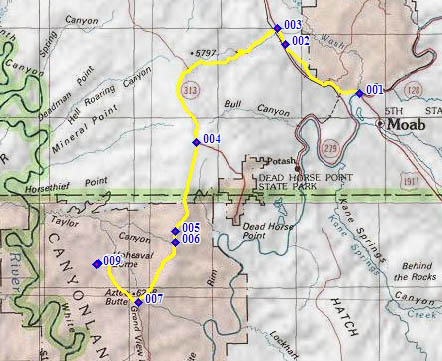
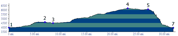
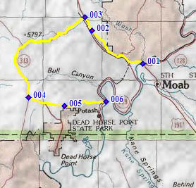
Rides with this point as highest summit: COMPLETELY PAVED ( < same page | Ut313 Gemini
Bridges Rd(sh) > ) P1: Ut313 Island in the Sky s(u) x2:
Willow Creek Rd <> Ut191 north <>
Ut313 east <> Island in the Sky s(u) x2
<> Upheaval Dom area with additional out and
backs to Green River Viewpoint and Grand
Viewpoint: 87.6miles with 4070ft of climbing in
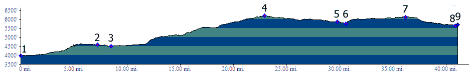
6:23hrs (r2:11.10.12) (pics t11_12_26-51) PARTIALLY PAVED / UNPAVED < ... | Hurrah
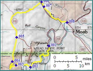
Pass > ) C2-1: same summit point: Willow Springs
Rd > US191 south > Moab > Ut279 west >
up Potash Rd > up Shafer Trail > Ut313
Island in the Sky s(u) > Ut313 west > Ut191
south back to starting point: 71.5miles with
4160ft of climbing in 6:20hrs (m3:7.5.23) (pics
_t07_1_38-75) ( < Ut313
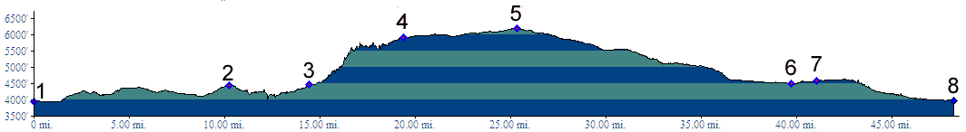
Spring Cayon Rd(sh) | same page > ) C2-2: Ut313 Island in the Sky s(u): Willow Springs Rd > US191 north > Ut313 east > Ut313 Island in the Sky s(u) > Dead Horse Point State Park with short detour > Pucker Pass(shp) > down Long Canyon Rd > Ut279 east > back to starting point on Willow Springs Rd: 65.4miles with 3500ft of climbing, time not recorded (m3:11.10.10) (pics:t11_12_1-25) History - Shafer Trail: In the beginning
- there were the animals. They were the first to
take advantage of the absence of sheer cliffs at
the particular spot where switchbacks now climb
from the White Rim. Sog Shafer noticed this and
constructed a cattle trail to the rim in 1917.
This way the cows could stay on top where it's
cooler for the summer, then in the Shafer Basin
for the winter. The reason for the road however has to do more
with money than anything else. Uranium mining
started to play a big role in the cold war and by
1952, trucks were hauling the stuff from the White
Rim Basin to the Mesa Top and via the Dubinky Mine
road to Moab.
back to cycling Utah's summits and passes |
||||||||||||||||||||||||||||||||||||||||||||||||||||||||||||||||||||||||||||
 Southern Approach: same as
above
Southern Approach: same as
above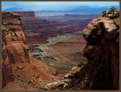
|
|
advertisement |
|
|
advertisement |