| |
| |
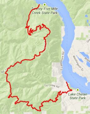
FR8410 Slide Ridge s(u)
This road seems to be well
known to many enduro type motorcycle riders. I
think it makes a great bike ride too. For me
the landscape here came as a big surprise. I
expected something resembling the Cascade
Mountains further west, something with lots of
needle trees and moss hanging from it. But I
wasn't even close. This far east, this is more
of a dessert range with open forest or
remnants of burn areas, another great facet in
the kaleidoscope of north western landscapes.
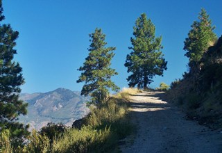
From North.South Lake Shore
road lazily meanders along the shore of this
wildly beautiful lake, until it comes to an end.
Not the lake - it is carved much further north
into the Chelan Mountains - but the road.
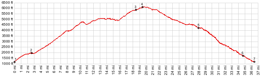
Turning into FR5900 to Shady Pass,
it steeply climbs away from the lake. This is
where the profile starts. Pavement continues to
the the signed junction with FR8410 Slide Ridge
Road. It dips into the forest to cross
Twentyfive Mile Creek and then starts on its
relentless climb up to Slide Ridge. The road has
been recently graveled (Sept/13). So this is not
the easiest climb. But it could be worse. The intial series of switchbacks
are across from the Shady Pass road, which also
climbs to lofty heights on the sparsely forested
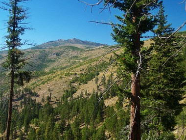
ridge across. Slide Ridge Road eventually gains
the ridge and Lake Chelan is imaginable from the
the pieces of images between the trees. But they
never open up to give a view. Now the road,
together with the ridge doubles back on itself,
and what where switchbacks yet to be climbed
just minutes ago, are now a low foreground for
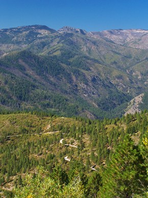
pictures of Chelan Ridge. Next the road negotiates the
gentle rolling ridge-line in the forest. Views
still open up periodically to the north. When
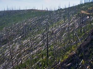
Slide Mountain comes into view, the world takes
on an apocalyptic feel. Whatever trees are left
standing are stripped bare (apparently) by fire.
The trees that are left hanging between others
form trapezoids of utter destruction. Now Lake
Chelan comes into sight again, and this time the
view remains to the top. My de Lorme map shows
the road ending at the top. This could not be
further from the truth. It keeps going, less
graveled to boot, so for cycling it actually
gets better. A trailhead marks the top.
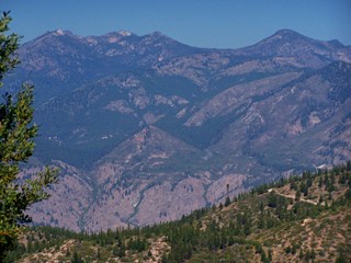
From South. (described
downwards). This picture of devastated forest
continues for many miles on this side, this time
backgrounded, by the high bare mesas,
surrounding Wenatchee. Looking down into the
matchstick forest a maze of roads seem to
crisscross the plateau landscape. Many of these
are abandoned logging roads, so the picture is
confusing. At the first intersection with a
non abandoned road, the profile stays left,
following a sign promising that the road is
closed 5 miles ahead. A right, according to the
map would stay on FR8410 and lead into the
Entiat River Valley, which is really too long
for a comfortable day loop. The descent aiming east is a fast
ride. At junctions I stayed left, unless they
clearly went steeply uphill. This did lead me
eventually to a closed gate, then more downhill,
then another gate, closed from the other side.
The route emerges on Wa971, immediately before
the turnoff to Bear Mountain Road. A sign reads
that the route is closed because of a "rope
course", whatever that means, and that the
forest service has not acquired public access
along the route. I spoke to some fire workers,
on the road further up, and they informed me
that it is possible to detour around the closed
access route, but it is not signed. Wa971 still has one superb view of
Lake Chelan in store, accompanied by the smell
of grapes and fruit, before the last downhill
leads back to the shore. There are no easily
recognizable businesses along the shore, where
one could get water, even though it is really
one endless parade of vacation housing. Dayride PARTIALLY PAVED / UNPAVED ( < Rainy Pass ,
No 2 Canyon Road s(u) | Junior
Point/Shady Pass > ) -
|
 Approaches
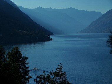
|
|
advertisement |
|
|
advertisement |