| |
| |
Old Blewett Pass
In Washington it is a good
sign when you see cryptic warnings painted on
the road. Instead of road signs, sometimes
there are circles around holes in the road, or
mysterious wavy lines - just before severe
sloughs appear. Sometimes downright clear
instructions are written on the road, such as
"slow". All of these symbols signal, that the
road sees few motor vehicles, and that it is
pretty much perfect for bicycling. Old Blewett
Pass is such a road. This old historic
crossing between the former, old mining town
Blewett and Cle Elum parallels the newer Blewett Pass
road, which was officially named Swauk Pass.
But for some reason the name did not stick.
The only problem with Old Blewett Pass is, that on both sides it eventually merges onto "new Blewett Pass", and all its traffic, zooming along with gas pedal fully depressed. But even here there is an excellent shoulder. Needless to say the entire Old Blewett Pass Road is a little rough for some skinny tire bikes. But it is fully paved from beginning to end.
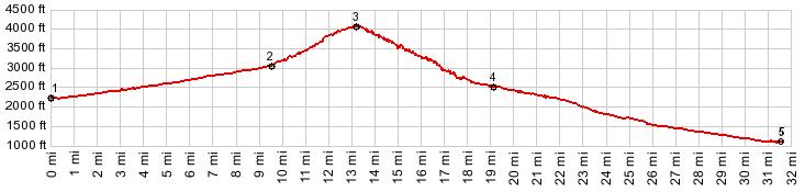
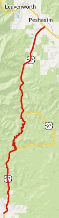
From South. The turnoff
from US93, Blewett Pass onto the old highway is
signed as "Old Blewett Road". The road zig zags
up the slope to the west until it arrives at
Biscuit Point (also called Echo Point). This
curve seems to swtich back more than 180
degrees. Obviousely this can't last too long.
There is also a view of the eternally wooded
hills from here. From here the road follows the
hillside in innumerable small curves, traversing
to the summit. From there you can climb higher
with a mountain bike on a trail. There are
several houses hidden in the adjacent woods, and
also a homemade "Old Blewett Summit" sign From North. The slope next
to the first curvy traverse after the summit is
so steep, it affords a good view to the east. he
curvy wavy nature of the road ends when crossing
two small bridges, 10mph max speed limit. The
turnoff from US93 on this side is also signed as
"Old Blewett Road". The road is the result of
improving the transportation situation for
mining. Starting in 1879, a horse trail was
improved into a toll road, so that gold ore
from Blewett on the north side of the pass,
could make its way south to Cle Elum. By 1910
only about 40 people remained in the former
small town.
In 1915, the road became part of a network of primary roads connecting east and west Washington. The new route on US97 was built in 1956. Officially the name "Swauk Pass" was attached to the new route. But people kept using the name Blewett Pass for the new route. 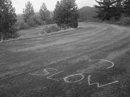 -
|
 Approaches
|
|
advertisement |
|
|
advertisement |