| |
| |
Paradise s(u)
There are two high viewpoint
roads on Mount Rainier, leading to Sunrise and
Paradise. This one is the lower of the two,
but also the only two way summit. It can be
made into a completely paved loop ride with
the help of Skate Creek Rd.
From West. The profile
starts in Ashford. I joined it a few miles up
from there at the junction with Skate Creek
Road. This was the beginning of a long
curvy ride through an interesting forest. The
grade picks up noticeably after Longmire. The
first moment when it felt really good to be on a
bicycle, instead in one of those thousands of
cars passing me, was when the road crossed the
Nisqually River. I think generally the traffic
is not that heavy. But I wanted to take
advantage of the unlimited sunshine, lasting
only two more days on this Labor Day weekend But back to the Nisqually River.
It gives the appearance of pouring down from its
source, the glacier, in a gigantic circular
staircase. The bridge is the perfect vantage
point onto it. The road continues to climb to
ever better vantage points, and from above the
proportions of the bridge against the gravel
canyon is even more impressive. Next a sign
presents the choice "Paradise" or "Paradise via
viewpoint" - Of course "via view point". This
option leads over the remnants of an older road,
complete with all the artistic stone railings,
still keeping people from falling off, and
looking very attractive doing it (the old
stonework, not the people). Meanwhile the had levels out and
the majority of the workout is over - I thought.
But the a road cut above appeared in view. A few
more switchbacks lead up the optional loop to
Paradise, complete with a hotel, a visitor
center, a gigantic parking lot with even more
people looking for a place to park, and also a
sublime view point onto the mountain. 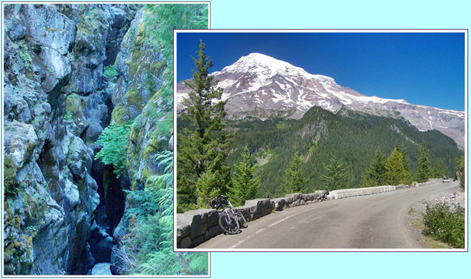 From East. (described
downwards). As I rolled down Valley Road, the
one way loop out of Paradise, it occurred to me
that Mount Rainier looks even more impressive
from a lower vantage point. As the bike rolled
on, my own vantage point was getting lower by
the minute, and the green pedestal set off by
black cliffs beneath, makes for a striking
contrast to all that ice, snow and glacial
cracks. The out and back loop soon joins
back to Wa206. On the map it crosses Pinnacle
Saddle. The spot is not signed on the road,
neither is there a clear summit point, but the
pinnacles to the south are definitely there.
This is a fairly amazing mountain range in its
own right. New additions to the Rainier
panorama appear, a series of lakes as
foreground, only the first one has a multitude
of cars parked next to it. The lakes below
retain their peace even on Memorial Day weekend.
A long descent leads to another stopping point:
an old stone bridge over a slot canyon, and
Mount Rainier above keeps only getting bigger.
After that there is one final view point from a
large parking lot, and it's time to say goodbye
to this awe inspiring spectacle. The green
Cascade hills below are still yet to be rolled
down. And till the long downhill merges onto
US12 and finally ends in traffic noise on a
spacious shoulder in Packwood, many, many
rolling miles are still ahead to be enjoyed. Dayride COMPLETELY PAVED: ( < Chinook Pass
| Cayuse Pass
> )
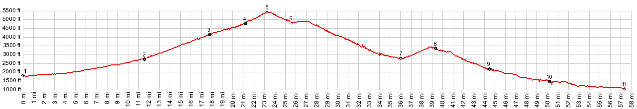
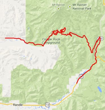
Paradise s(u) , Skate Creek road s(u) : jct FR47 - US12 > US12 west > Packwood > Skate Creek Road north > Skate Creek Road s(u) >Longmire > Paradise s(u) > Ohanapecosh > back to stating point : 84.5miles with 6070ft of climbing in 6:32hrs (m5: VDO MC1.0 13.8.31) Notes: this route is completely paved, even though I was told otherwise at the Mt Rainier entrance station the day before - |
 Approaches
|
|
advertisement |
|
|
advertisement |