| |
| |
Baldy Pass
Shell Canyon on the west side of
Granite Pass
is the scenically most exciting paved climb in the
Bighorn Mountains - in my opinion. But, the west
side of Baldy Pass is the steepest, and with that
the hardest climb - and that is not just an
opinion.
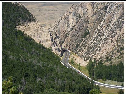
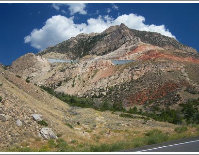
Most US roads, that were built during the popular road building days of post WW2, have gentle grades, somewhere around 6 or 7 percent, so that Yellowstone bound tourists are not needlessly detained from their preordained appointment at Geyser Lodge, by suffering the indignity of having to shift gears. Much of the current road bed to the west of Baldy Pass is the result of a reconstruction, finished in 1983 with steeper than normal grades. It contains long 10 percent grade sections, and signs along the way try to create the impression, that you are about to endanger your life when entering this area. I imagine this is for the benefit of truck drivers with brake maintenance issues. The steep sections have very few turns, and that somehow fits in with the endless views of the massive dessert below, and the sweeping carpet quality of the plateau on top.
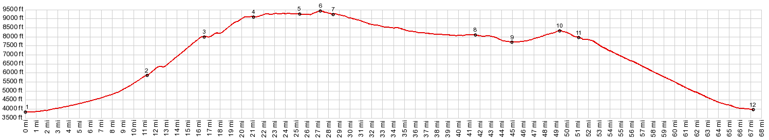
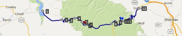 From West. The bottom of this profile is
the causeway and bridge across Bighorn Reservoir,
east of Lovell. This is already a scenically
wondrous area. The Shoshone River's meanders are
still visible inside the reservoir. It leaves soft
wetland boundaries, that have formed on its
shores. The first part of the climb is a six mile
stretch, climbing almost imperceptively with a
single slight bend, parallel to the exposed
geology of the Bighorn Mountains. There are quite
a few double trailer trucks on this road. But they
all turn off before the mountains really start.
Most of the shoulders have been rumble stripped,
sometimes down the middle, sometimes so that
riding on the shoulder is possible only with
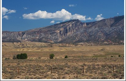
difficulty. But traffic is light. Now the road turns up into the alluvial deposits
in front of the range and the climbing becomes
definitely noticeable. Layer cake badland hills
appear to the north east and progress is gauged by
how the perspective on these low hills changes.
At 5770ft is an interesting junction. The old
Dayton - Kayne Highway, the predecessor of the
current US14Alt roadbed branches off to the left,
apparently still paved. I decide to take it. But then my mood improves, as I find two separate
groups of tourists in camping vehicles, willing to
sell me water - actually they want to give it to
me, so that I can deal with the 90 plus
temperatures and the additional 1000ft of climbing
after returning to the junction. There are some great views with US14Alt in the
foreground from this point. Here a short
relaxation phase begins, as I traverse along what
appears to be the edge of the plateau. The cool
air from the top is blowing against me, giving
relief from the August heat for the first time. A
parking lot the size of a conference center
contains two informational signs, scattered about
the large area, so that tourists actually drive
their cars from one sign to the other and exit the
car a second time in order to read it. I watched
this several times during my lunch break. The rest
area here is called a "brake cooling area". After that comes another climbing section up a
straight ramp, with the road turning barely a
single degree, before reaching the next truck
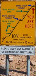
runaway ramp on the other side. When the flowing
green hills on top come into sight, a sign
instructs drivers to "study the sign carefully".
It shows the three ten percent grades with
dramatic horizontal exaggeration. But that is
behind me and I continue to climb in a straight
line.
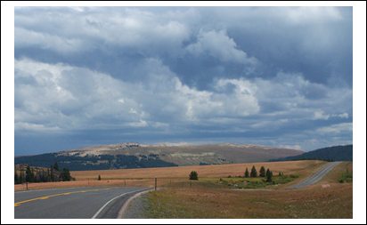
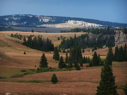
The road to Baldy Pass follows a gentle grassy
valley along the North Tongue River. Every couple
of miles a grassy track leads to a fishing area.
Just as often a rocky ledge peaks through the
forested hills. Approaching the top the grade
becomes a little steeper and the landscape turns
to endless grassy hills, spreading out like a cool
high carpet between 9 thousand and 10 thousand
feet in elevation. The pass summit is at a curve
that reveals a stunning far view of the Bighorn
Basin and its rippled badlands below. The top has
the typical-for-Wyoming overly spacious parking
lot. The sign says nothing about Baldy Pass.
Instead it states: "Observation Point 9430ft". But
the name Baldy Pass is used on many maps and
commonly used. Dayride with this point as highest summit: COMPLETELY PAVED: ( < sama page | Tunnel Rd(sh?) > ) PARTIALLY PAVED / UNPAVED ( < FR17
Paintrock Road s(u) | same page > ) History Modern Roads: The east side was opened first to get mining equipment to the top of the pass to what was then the Fortunate Mine in the 1890s. In 1912 this access from the east was on its way to being improved, By this time gold mining was already history. At the same time the first track up the western side was established. It was known as the Salt Road, because it was used to transport salt to summer pastures. In 1922 this high pass was planned to become part of a highway between Sheridan and Greybull. By 1932 this had become a through going road with a width between 10 to 24ft. It was already paved by the mid 1930s. The original 14A, much of which has now been destroyed was known as the Dayton-Kane Road for the two towns it connected. Today you can't find Kane on the map, because it is located at the bottom of Big Horn Reservoir. Construction on the current road bed started with a bridge over the Bighorn Lake Causeway in the 1960s. It took till 1983 till the road was completed. The construction has five reinforced earth walls with an unusual construction, where the outer retaining wall is made from metal strips. |
 From
East. (also described upwards) Crossing the
Bighorn Mountains east to west on pavement always
involves two summit points, even if the eastern
summits don't receive much attention. But they are
separated by drops greater than 500ft. On US14
it's
From
East. (also described upwards) Crossing the
Bighorn Mountains east to west on pavement always
involves two summit points, even if the eastern
summits don't receive much attention. But they are
separated by drops greater than 500ft. On US14
it's |
|
advertisement |
|
|
advertisement |