| |
| |
FR168 Freeze out Rd(sh)
Freezeout Rd is an interesting
park like point on the easternmost ridge of the
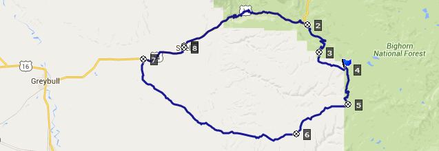
Bighorn Mountains above Dayton. This loop looked
pretty straight forward on the map. But connecting
Freeze out Rd with the town in front of the
mountains, turned out to be not so straight
forward as the map may lead to suspect.
US14 climbs up to Burgess Jct, with its elaborate
closed visitor center and then turns onto FR15.
This is a wide gravel road, that is not perfect
for bicycling. So I turned off onto FR168 which
looks like a short cut on the map and has a
surface very agreeable for mountain biking. But
this options has its own price. The track crosses
a small stream and then climbs steeply back out of
this peculiar ravine, to join FR15 again. This
road climbs into a forest with good far views
bordered by planar caprocks turned on edge, that
border off grassy rangeland from wedges of forest.
In my case the views were flattened by dense
smoke. The road surface becomes much better as the
road passes some of the most luxurious wild
camping sites I have ever seen. And yes it really
does feel remarkably cool to cold here.
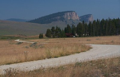
Approaching the top, the area is bordered by a row
of low rocks on one side, giving it an intimate
park like setting. The good dirt road simply makes
a dead end loop here.
From East. There are
some nicely bikable tracks on this side. However,
following the route down all the way to Dayton on
FR181 and whatever comes after it, this one of
those routes, where I wonder if anybody has ever
dragged a bicycle here before. The first descend
is relatively benign and ends at what looks like a
vacation home, but apparently is a cow camp - a
very attractive cow camp, at least from the
outside. Climbing again from here towards the left on
FR182, conditions become very rocky, and on my
trip, I see that I am directly above a forest
fire, but luckily a canyon separates me from it.
The road's objective is to reach the Smith Creek
drainage.
A ride with this point as intermediate summit
is on page: Cutler Hill
s(u) |
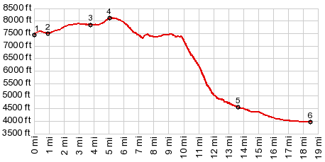
 But the profile contines on a much
rougher track, FR168 towards the highest hill in
sight. But before reaching the highest point, the
profile turns down the more traveled looking FR199
on the left. The summit point as I remember it, is
right at the intersection. The gps however says,
that it was before the intersection on FR168.
But the profile contines on a much
rougher track, FR168 towards the highest hill in
sight. But before reaching the highest point, the
profile turns down the more traveled looking FR199
on the left. The summit point as I remember it, is
right at the intersection. The gps however says,
that it was before the intersection on FR168.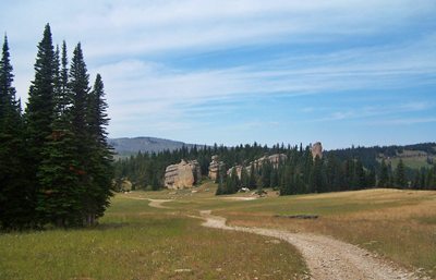 Here an extremely steep double
track trail starts. The first part is too steep
and rocky for riding. The second part is just
plain too steep, except for a few short stretches.
The view from this open meadow would be
exceptional if it wasn't for the smoke. At the
bottom, the trail becomes an awkward fenceline
trail, that follows a private land boundary
resembling the death zone fence along the old
Berlin wall. Most of the trail is overgrown by
high grass, but it is possible to follow it on a
bike, and even ride much of it. At the end the
track simple leads across a field to the Amsden
wildlife area, where a couple of fire fighting
officials telll me more about the fire currently
being fought. I exit the closed off area on the
Amsden Wildlife area access road to Dayton.
Here an extremely steep double
track trail starts. The first part is too steep
and rocky for riding. The second part is just
plain too steep, except for a few short stretches.
The view from this open meadow would be
exceptional if it wasn't for the smoke. At the
bottom, the trail becomes an awkward fenceline
trail, that follows a private land boundary
resembling the death zone fence along the old
Berlin wall. Most of the trail is overgrown by
high grass, but it is possible to follow it on a
bike, and even ride much of it. At the end the
track simple leads across a field to the Amsden
wildlife area, where a couple of fire fighting
officials telll me more about the fire currently
being fought. I exit the closed off area on the
Amsden Wildlife area access road to Dayton.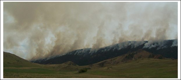
|
|
advertisement |
|
|
advertisement |