| |
| |
Grand Targhee ski area summit(u) A ride to the Grand Targhee ski
area is one of very few two-way summits into the
Teton Range. I only know of two, this one and
Teton Pass. This may sound like an out and back
ride, but with a mountain bike you can continue
climbing past the ski lodge and take a somewhat
different way back down to the base station, voila
two way summit.
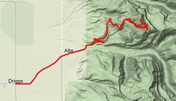
From West -1. The turnoff from Driggs to the Grand Targhee resort is located in the center of town and it is signed. A wide paved road starts to climb at an imperceptible rate towards the Teton Range. Like most other towns in scenic locations, Driggs has its new luxury real estate developments on the outskirts, and this road passes them. Here the houses seem to be a lttlemore discretely hidden in the woods than in other locations, like Jackson. The first views of the Tetons show up as the road passes a guest ranch. The slope increases noticeably past the dirt road turnoff up Teton Canyon. Immediately afterwards a wide scenic switchback gives the impression of a rugged alpine roadway. But then the road hides in the forest again. There is a wide shoulder for climbing and traffic is extremely light in summer, which makes for a very pleasurable ride. Before the base station of the ski area the road climbs a very small saddle and descends to the lodge. On the right side in the main passage of this
base station is a information room that dispenses
little maps for hiking and biking, as well as
verbal advise. The service road to the highest
point in the ski area is termed "Teton Vista
Traverse" on this map. It begins to the right of
the lift, then a left following immediately
afterwards and right immediately after that. The
service road climbs steeply and is bordered on the
right by a drop that slowly grows into a canyon.
Much of this road is too steep for riding. After
roughly two thirds of the way to the summit the
road veers left and now assumes the proper slope
for riding, while views of Teton Basin become
better and better. Turning just at the right
moment you may also see the highest peaks in the
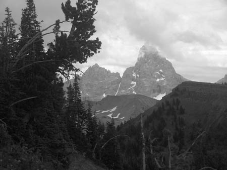
Teton Range. Back to the right on top of Fred's
Mountain the road and lift end. A few feet of
walking will get great views of the ranges to the
east. Most of the picture in the photo page were
taken from that single vantage point.
From West -2. The descent back down to the base station is strictly speaking a different route, but it parallels the service road closely. The ride is different but the views are very similar. The "sidewinder-trail" is the most obvious way down. It stays uphill parallel to the road for the inital traverse, then crosses to the north side of the road to wind through fields of wild flowers in the summer. There are several banked turns along the way. Approaching the lodge the trail takes several long switchbacks across the road and the slope becomes shallow. All 3.9 miles are extremely rideable. Shortcuts over steeper terrain are also available. The trail is mostly used downhill even though no regulations state this. The profile on this side is an approximation and
reality contains many more small ups and downs
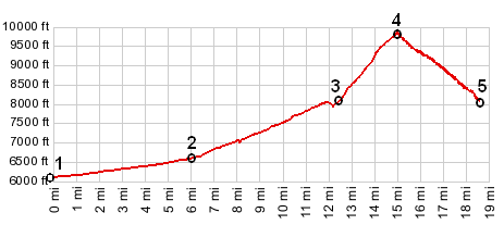
that do not show up on the profile. Dayride PARTIALLY PAVED / DIRT ROAD / SINGLE TRACK A mostly out and back ride from Teton Canyon
campground > down Teton Canyon > up paved
FR25 > Grand Targhee resort base station >
up service road to Fred's Mountain > Grand
Targhee ski area summit(u) > down Sidewinder
trail > down paved FR25 > Driggs > back
up FR25 and Teton Canyon to starting point: 42
miles with 4000ft of climbing in 4:2hours
(m3:10.8.9).
|
 Approaches
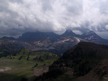
|
|
advertisement |
|
|
advertisement |