| |
| |
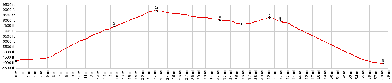
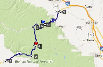
Granite Pass
Three paved roads cross the
Bighorn Mountains in north central Wyoming. They
all summit within 400ft of elevation. But
this one is the lowest of the three and
geographically situated between the other two.
Arguably it is also the most scenically
spectacular and unusual of the three - not because
of the summit, but because of Shell Canyon on the
lower western approach.
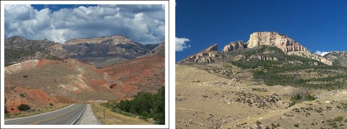
From West. It's from
this side that the Bighorn Mountains show their
most unusual and spectacular side. Rolling into
Shell from the west on US14, the massive limestone
layers behind Shell appear like a patterned wall,
behind a colorful dessert that you might expect in
southern Utah. The profile starts in Shell, population somewhere
below a hundred, according to the sign. There is a
campground and a cafe here, and the people behind
the counter are usually working somewhere around
the property. Most of the yards look like they are
spacious town parks, but are actually really
private lawns. The large, old Cottonwood trees
give the place an oasis like character. Just north of Shell the road crosses Shell Creek,
the rivulet that eroded all this massive grand
scenery ahead on this ride, and with that the road
reaches a low point, and the profile finally
starts. Heading for the mouth of the canyon, it
sure looks like you are descending towards it. But
the tilted rock layer play tricks on the
perception. Only during the last short distance
before entering the canyon, does the road drop a
small amount.
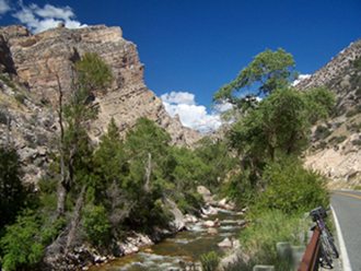
Initially the road stays immediately next to
Shell Creek, negotiating the narrowest and deepest
part of the canyon. At a bridge a trail following
an old livestock driveway allows exploring the
northside of the canyon, while the road stays on
the south. This trail also reaches the top of the
plateau These spectacular canyon walls are formed by two
consecutive limestone formations, one on top of
the other: the Missippian Madison limestone on the
bottom, upon which the Ordivician Bighorn dolomite
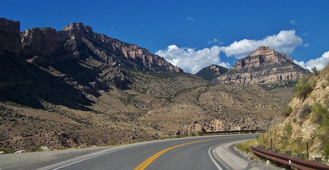
is stacked. As the canyon becomes much wider, the road climbs
partially up the north side of the canyon with
wide sweeping turns. The road has a shoulder, but
unfortunately it has been rumble stripped in the
middle. Still, the shoulder is wide enough that
you can still ride to the right of the rumble
strip. Further up the rumble strips have been
paved over (Aug 2015). The mountains across the canyon seem unclimbable,
bordered by ledges on all sides. The most unusual
looking is Copman's tomb, which resembles the
teeth in a mouth with extreme tooth decay, with a
little imagination. From this vantage point you
would never guess that zones of dense forest wait
on top of this plateau. At about 6200ft the road reaches Shell Falls, for
many drivers the first reason to exit their
enclosures. Paradoxically this point also marks
the end of the spectacular canyon section. Above,
there is still the occasional slot like canyon cut
into precambrian granite, dissecting the
landscape into cracks, but still, it looks
comparable to other canyons around here. Up ahead large boulders from a higher formation
lie in the middle of the gentle valley, like big
bread crumbs on a rumpled table cloth. This is
where FR17
takes off toward Paintrock to the north. The
road makes one more switchback and looking back,
the limestone cliffs are now below eyelevel. The scenery takes on more and more of a high plains character, and the road levels out to near zero grade. Still, just before reaching the summit, the road climbs a minute amount to make the whole thing just a little pass-like. There is a single Granite Pass sign on top, facing west, as well as signs announcing the change in counties. There is no shoulder on top, but traffic is generally light.
From East. The profle starts in Dayton, at
the edge of the Powder River Basin. On this side
the road crosses another summit first, Cutler Hill
s(u). Following a 700ft drop, this profile
stays left on US14 and follows a gentle grassy
valley uphill. In August long rows of trailers can
be seen lining nearby meadows at the edge of the
forest. It seems many people just park their
trailers somewhere in the Bighorns even if they
are only there for a couple of weekends. Others
groups of these nomadic settlements are surrounded
by every type of motor contraption that you can
think of. I never saw a single bicycle, except the
one I was riding. - Too bad.
A Dayride with this point as intermediate
summit is on page: FR17
Paintrock Road s(u) |

|
|
advertisement |
|
|
advertisement |