| |
| |
White Mountain Road via Rock
Springs(sh) This is a point on the Wild
Horse Loop Rd. The highest section
of this road is approached by an
additional very steep approach from Rock
Springs. At the top of this approach you
can turn right and cross the highest point
on the Wild Horse Loop. If you turn left
or west, this point becomes the summit
point, but only by 30ft or so. Both
options are scenically fascinating. The
option turning left (shown in the profile
below) has a better road surface.
Once on this suburban drive,
the preferred mode of habitation soon
changes to trailers. After leaving behind
the last homesteads of this kind, a road
sign names this as "White Mtn Rd". This can
be confusing, because it is the same name as
the name applied to the road following the
rim on top of the mountain. But we are not
there yet. One White Mtn road ends at
a T-junction with the other White Mtn Rd.
To avoid confusion, some maps use the
name "Gookin - White Mtn Rd" The road has a
fairly hard surface, and it soon becomes
extremely steep, so that the 1300ft of
climbing may seem like much more. A
transmission tower at the jct with the real
White Mtn Rd serves as sign of progress, but
only during the last 400 ft of climbing. Turning left at the junction
one of the next bumps along the way is the
highest point
From
West. This is pretty much the same as
the western approach to Wild
Horse Loop s(u). It is a much gentler
road and more suitable for climbing on any
kind of muscle powered transportation
device.
Dayride with this point
as highest summit:
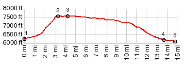
PARTIALLY PAVED / UNPAVED ( < Wild Horse Loop s(u) | Aspen Mountain Road s(u) > ) White Mtn Rd via Rock Springs(sh) : near several miles up White Mtn Rd from Green River > White Mtn Rd east > unsigned intersection with 3 additional tracks at 7100ft > unsigned track north then east <> out and back on unsigned track south to overlook over Green River, western part >> unsigned track south > jct Blue Mtn Rd - I 80 > Green River with several miles of sightseeing detour on south side of the river > I80 east > Rock Springs with sightseeing detours > Gookin - White Mtn Rd north > White Mtn Rd west > White Mtn Rd via Rock Springs(sh) > back to starting point near White Mtn Rd: 49.4miles with 3030ft of climbing in 4:55hrs (garmin etrex30 m3:20.9.23) 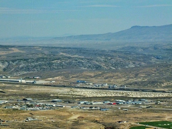 |
|
|
advertisement |
|
|
advertisement |