| |
|
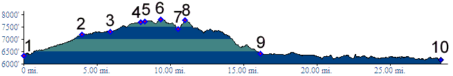
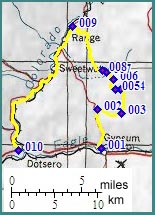
01.(6330ft,mile00) START-END EAST:
I70 exit to Gypsum
02.(7200ft,mile04) go right at this major intersection
03.(7320ft,mile07) stay left
04.(7690ft,mile08) right goes to higher area adjoining Castle Peak WSA. But profile continues left.
05.(7730ft,mile09) profile continues right at this signed intersection. Left follows Agnew Gulch and rejoins CR71.
06.(7810ft,mile10) TOP: point of highest altitude
07.(7410ft,mile11) bottom of Greenhorn Gulch
08.(7780ft,mile11) intermediate top
09.(6420ft,mile16) route joins paved Colorado River Road. Continue left
10.(6160ft,mile29) START-END WEST: Dotsero