| |
| |
BLM8479 shoulder summit(u):
Gypsum Hills
When driving west on I70 from
Denver for the first time - over Vail Pass - emerging
onto the western slope, the change of the
landscape is a real spectacle. The snowy
continental divide is now behind on the horizon.
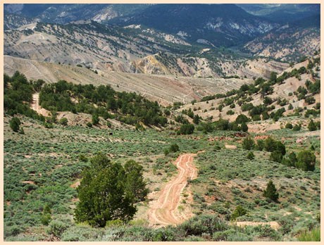
Now the road is in a deep dry trough of light
colored, muddled badland rocks. Much of the
surrounding wild high plateaus near Gypsum and
Eagle are in the hands of large private land
holders. But there are a few access roads left,
that still allow access for anybody to marvel at
the unique landscape of the Colorado River Valley,
as it makes the transition from a high alpine
stream to a canyon carving monster. The I70 exit
in Gypsum provides access to several unnamed
summits and shoulder summits in the Gypsum Hills.
It always amazes me to see these hills free of
snow when Cottonwood
Pass to the south of Gypsum is still ( or
already ) covered in deep snow.
A slightly higher altitude is reached by expanding the loop between points 3 and 4 to the east. But this option does not add much in the scenery department. The highest point on that loop is a shoulder point on a loop adjoining the Castle Peak WSA, which is a completely different ride.
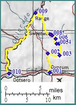
From East. The profile starts at the
Gypsum I70 exit. CR51, a wide dirt road, suitable
for heavy industrial traffic winds its way into
the dry hills to the north, complete with guard
rails on a rough medalled surface. The reason for
the road width soon becomes apparent, the Eagle
Gypsum mine. Past that road conditions are
less predictable. During my last visit the surface
was a hard smooth clay, eroded into deep gullies
and troughs, which is really quite pleasant to
ride and helps keep motorized traffic down. The
profiled route diverts from CR51 at a large
intersection that has a map posted, but no road
numbers or identifying location. Going right the
route contours near the edge of the hills, passes
a few marked and unmarked turnoffs to the right,
goes past a car graveyard that predates the Gypsum
suburban style developments (picture below).
Meanwhile the Sawatch Range makes an appearance on
the south eastern horizon and Mount Scorpris
points its snowy triangle above the juniper hills
further west. After a short rocky stretch, another
intersection forces a choice between heading
direction Castle Peak, or as the profile does,
left towards the Colorado River. The next
intersection is signed, and the route follows the
Colorado River option. The point of highest
altitude is reached after a short descent and a
short steep climb.
From West. The approach is described in a
downward direction. A series of straight stretches
follow fenceline boundaries, marking a wilderness
study area and further down a vegetation study
area. The straight trajectory of the road makes
for many steep up and downs. The full height of
the Flattops plateau on the other side of the
Colorado River becomes apparent, with its snow
capped ledges below the clouds and the brittle
grey badland hills or solid red layer rocks,
draping down to the river. BLM 8479 emerges onto
pavement approximately across from the driveway of
a farm adressed as 12799 Colorado River Road. The
turnoff is an unlocked fence gate labeled with a
BLM road number and "public access through private
land" sign. The profile follows Colorado River
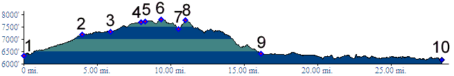
Road back to Dotsero. Dayride with this point as the highest summit: PARTIALLY PAVED / UNPAVED BLM8479 Gypsum Hills s(u): A 9
shaped ride, starting at the I70 Hanging Lake
exit, going to Gypsum, crossing the shoulder
summit as described and returning via Dotsero and
the Glenwood Canyon bicycle path measured 53 miles
with 3600ft of climbing in 5:0 hours
(m3:07.05.13).
|
 Approaches
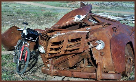
|
|
advertisement |
|
|
advertisement |