| |
|
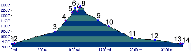
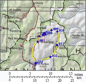
01.(9300ft,mile00) START-END SOUTH: Silverton
02.(9330ft,mile01) go straight up Cement Creek road, while main road turns right.
03.(10460ft,mile07)go left up steep dirt road in mining camp of Gladstone
04.(11500ft,mile09) jeep trail from Corkscrew Gulch joins from left.
05.(12290ft,mile09) jeep trail to Sunnyside Saddle leaves on right
06.(12407ft,mile11) Hurricane Pass
07.(12300ft,mile11) Poughkeepsie Gulch Trail leaves downvalley to left. Route to California Pass continues to right.
08.(12930ft,mile11) TOP: California Pass
09.(11550ft,mile14) road from Placer Gulch joins from right
10.(10960ft,mile16) Animas Forks. Junction with Engineer Pass, Cinnamon Pass and Denver Pass to left. Another trail slightly upvalley on this profile also joins to this road.
11.(9850ft,mile20) Eureka
12.(9680ft,mile23) Howardsville; road up Cunningham Gulch leaves on left
13.(9330ft,mile27) same as point 2.
14.(9300ft,mile28) START-END NORTH: Silverton