| |
|
-
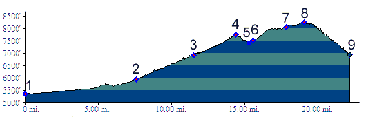
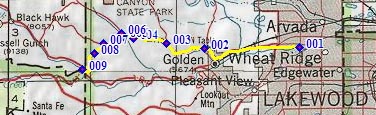
01.(5360ft,mile00) START-END EAST ALT: Wheat Ridge, jct: Clear Creek bike path - Kippling Ave.
02.(5930ft,mile08) START-END EAST: beginning of Golden Gate Canyon Road, just north of Golden
03.(6920ft,mile12) Crawford Gulch Road diverts on right
04.(7750ft,mile15) Golden Gate Pass
05.(7430ft,mile16) intermediate low point
06.(7530ft,mile16) profile turns hard left onto Robinson Hill Road
07.(8070ft,mile18) Robinson Hill Road continues right, while this route stays left.
08.(8240ft,mile20) TOP: point of highest altitude
09.(6950ft,mile22) START-END WEST: jct Douglas Mtn Road - Co119 south of Blackhawk
-