| |
|
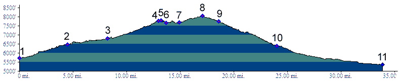
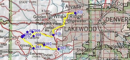
02.(6470ft,mile05) Idledale and (dirt) turnoff to Grapevine/Sawmill Gulch is on right. Profile continues straught.
03.(6810ft,mile08) profile turns right up Kerr Gulch, just before turnoff to Parmalee Gulch (aka Myers Gulch or Dix Saddle) and town of Kittredge
04.(7780ft,mile14) profile joins Co74 and turns right to El Rancho
05.(7810ft,mile14) Kerr Gulch - Co74 shoulder point
06.(7670ft,mile14) El Rancho
07.(7680ft,mile15) Chief Hosa exit on I70; short dirt stretch starts here
08.(8060ft,mile18) TOP: Genesee Mtn summit(u). Out and back road continues higher to the left
09.(7740ft,mile19) route continues down Mount Vernon Canyon
10.(6400ft,mile24) START-END NORTH ALTERNATE: I70 exit for Morrison.
11.(5540ft,mile34) START-END NORTH: jct Clear Creek bike path - Kipling Ave.