| |
|
|
|
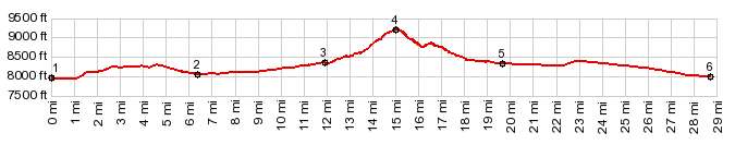
1.(mile00.0,7950ft) START-END WEST-1: beginning of Ice House Rd, south of the tracks, on the east side of Fort Garland
2.(mile06.4,8050ft)Britain Rd turns right onto Beekmap Rd
3.(mile11.9,8360ft)route turns left from Indian Creek Rd up Bear Creek
4.(mile15.1,9240ft)TOP: Kerp Rd s(u)
5.(mile16.7,8330ft)profile leaves Forbes Park and turns left onto US160
6.(28.7mile,7990ft)START-END WEST-1: US160 starts to parallel Ice House Rd, just east of Fort Garland
|
|