| |
| |
Kerp Road s(u)
This is definitely the most
unusual bike ride, at least for this year. This
summit has some things in common with a popular
Denver area cycling summit: Montane Drive s(u)
in the hills around Genesee. Like Montane Drive,
this road winds around in scenic loops to connect
expensive real estate investments. Rather than to
go from point A to point B, the objective here is
to show off the landscape to perspective
investors, and demonstrate that traffic volume
will always be reasonably low, with all these
extra curves and hills to negotiate on each
commute. This also makes for good bicycling
conditions.
Other aspects for this summit on
Kerp Road are very different. For one thing - none
of the houses have been built yet, and the roads
are dusty dirt roads. The panoramic vistas on this
ride are not of Mount Evans and the Front Range,
but of Mount Blanca, Ellingwood and Little Bear,
the southern terminus of the truly alpine part of
the Sangre de Cristo Range. This road winds
through land of the Costilla Ranch and the Forbes
Ranch - the legendary land grab, which again
proves that not all dollars have been created
equally.
From East. This side
is just as steep as the other, maybe steeper.
Perspective investors probably hope it doesn't
snow much here. If I have to push my bike up some
stretches, it will be hard to get that status
symbol automobile up here. The road quickly heads
back down to Beekman Rd, the same road that
branches off US160 on the western approach. From
this side you can access US285 at a more easterly
point via CR25. The profile goes back down US285
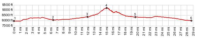
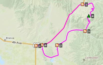
to meet up with the western approach. Dayride with this point as highest summit: PARTIALLY PAVED / UNPAVED ( < Cucharas Pass | FR330 Greyback Mtn s(u) > )Kerp Road s(u) , additional out and back: Smith Creek Reservoir > various sideroads to Fort Garland > Icehouse Rd south east > Trinchera Ranch Rd south > Brittain Rd > Beeckman Rd <> out and back to gate on Indian Creek Rd > up Mallott Rd > Spring rd > Kerp Rd s(u( > Lewis Smith Rd <> out and back to end of Beekman Rd at Forbes Ranch gate >> across rr tracks <> separate out and back up Merlo Dr > Kline Lane > turaround point near jct with Botman Dr >> down Beekman Rd > US160 west > Fort Garland > Blanca > Airport Rd south > back to starting point: 62.5miles with 3700ft of climbing in 5:45hrs (VDO MC1.0: m5:14.9.25). Notes: This is a more round about approach on the western side than in the description
|
||||||||||||||||||||||||||||||||||||||||||||||||||
|
|
advertisement |
|
|
advertisement |