| |
| |
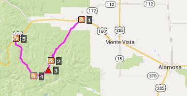
FR330 Greyback Mtn/
Summitville s(u)
We have to thank the early
miners of Colorado for a profusion of
exceedingly rough dirt tracks and jeep roads
in this state. But for this road we have to
thank the people who clean up after the
miners, and for that you need a much bigger
and more elaborately engineered road. This
road is used to clean up the Summitville
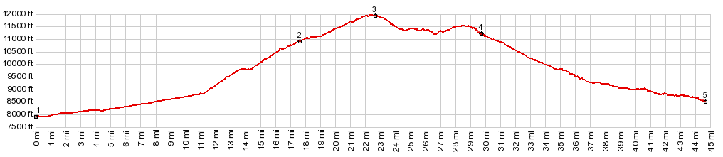
superfund site. The highest point on this road
is below Greyback Mtn, reaching almost
12000ft.
This summit is located on the Great Divide bicycle route. My first edition of the book, describing the Great Divide Route attaches the name "Indiana Pass" to this point. But I can't find this name used anywhere else and it is not listed in Helmuth's book "Passes of Colorado".
The lower part of this approach is a long steady gravel road climbing in forest. But there is also a long section through open rangeland south of Del Norte, before you climb into the forest. During my last ride in this area the upper section of the road was very smooth, you could call it hard medalled, making for fast aerobic cycling. At about 10500ft the road splits into a long rolling approach to Blowout Pass and a steady climb to Greyback Mtn. There are really no far views until you reach the top. There it becomes clear, that you are on a high disected plateau. From here to Summitville the road has the best above treeline views. From West. (also
described upwards) Roads approach Summitville
from below in almost a star like fashion. For
the profile I picked the most direct options,
that do not involve any other close by summit
points, like Elwood
Pass, Blowout
Pass, or FR360
Prospect Mtn s(u). FR360 leaves from South Fork and
just keeps on climbing through the forest
forever. There have been times when this road
was deeply graveled and a torture to ride. Other
times it's more like a road bike ride, but on a
mountain bike. About 500ft or so before FR360
reaches its own summit, FR330 to Summitville
stays left. The road soon reaches a sliced off
triangular mountain, with a few adjoining old
buildings crumbling into dust, which give just a
slight touch of historic decay to the area. A
substantial drop after the mine leads to another
climb. The road tops out just below the turnoff
for the jeep trail to the top of Greyback Mtn,
where a radio tower stands. There is a small
sign at this location marking the elevation at
11910ft. Immediately before the highest point is
also the trailhead for the TR700 Dry
Creek Trail. This trail is much more
interesting and scenic than the name would lead
to suspect. Dayride with this point as
highest summit: COMPLETELY UNPAVED ( < Kerp
Road s(u) | Stunner
Pass > )
- |
|||||||||||||||||||||||||||||||||||||||||
|
|
advertisement |
|
|
advertisement |